
Topografische kaart Irapuato
Interactieve kaart
Klik op de kaart om de hoogte weer te geven.
Over deze kaart
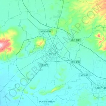
Naam: Topografische kaart Irapuato, hoogte, reliëf.
Locatie: Irapuato, Guanajuato, 36500, Mexico (20.51588 -101.51211 20.83588 -101.19211)
Gemiddelde hoogte: 1.763 m
Minimale hoogte: 1.691 m
Maximale hoogte: 2.345 m
It has a humid subtropical climate (Cwa in the Köppen climate classification) with an average temperature of 20 °C (68 °F). The large majority of rainfall occurs from June - September. It is at an altitude above sea level of 1,724 meters (5,656 ft).