
Doe een donatie
Rust jezelf uit voor je volgende avontuur:
Als Amazon-partner verdient deze site een commissie op in aanmerking komende aankopen, zonder extra kosten voor jou.
Topografische kaart West Nipissing
Klik op de kaart om de hoogte weer te geven.
Doe een donatie
Rust jezelf uit voor je volgende avontuur:
Als Amazon-partner verdient deze site een commissie op in aanmerking komende aankopen, zonder extra kosten voor jou.
Over deze kaart
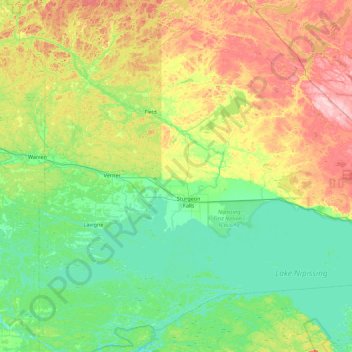
Naam: Topografische kaart West Nipissing, hoogte, reliëf.
Gemiddelde hoogte: 238 m
Minimale hoogte: 183 m
Maximale hoogte: 346 m
Doe een donatie
Rust jezelf uit voor je volgende avontuur:
Als Amazon-partner verdient deze site een commissie op in aanmerking komende aankopen, zonder extra kosten voor jou.
Andere topografische kaarten
Klik op een kaart om zijn topografie, zijn hoogte en zijn reliëf te bekijken.
Smoke Lake
Canada > Ontario > Nipissing District > Unorganized South Nipissing
Gemiddelde hoogte: 439 m
Doe een donatie
Rust jezelf uit voor je volgende avontuur:
Als Amazon-partner verdient deze site een commissie op in aanmerking komende aankopen, zonder extra kosten voor jou.
Doe een donatie
Rust jezelf uit voor je volgende avontuur:
Als Amazon-partner verdient deze site een commissie op in aanmerking komende aankopen, zonder extra kosten voor jou.
Arrow Lake
Canada > Ontario > Nipissing District > Unorganized South Nipissing
Gemiddelde hoogte: 414 m
Doe een donatie
Rust jezelf uit voor je volgende avontuur:
Als Amazon-partner verdient deze site een commissie op in aanmerking komende aankopen, zonder extra kosten voor jou.
Madawaska Highlands
Canada > Ontario > Nipissing District > Unorganized South Nipissing
Gemiddelde hoogte: 371 m
Doe een donatie
Rust jezelf uit voor je volgende avontuur:
Als Amazon-partner verdient deze site een commissie op in aanmerking komende aankopen, zonder extra kosten voor jou.
Princes Lake
Canada > Ontario > Nipissing District > South Algonquin Township
Gemiddelde hoogte: 467 m
Doe een donatie
Rust jezelf uit voor je volgende avontuur:
Als Amazon-partner verdient deze site een commissie op in aanmerking komende aankopen, zonder extra kosten voor jou.
Rose Lake
Canada > Ontario > Nipissing District > Unorganized South Nipissing
Gemiddelde hoogte: 459 m
Doe een donatie
Rust jezelf uit voor je volgende avontuur:
Als Amazon-partner verdient deze site een commissie op in aanmerking komende aankopen, zonder extra kosten voor jou.
Bellwood
Canada > Ontario > Nipissing District > South Algonquin Township > Whitney
Gemiddelde hoogte: 410 m
Carcajou Lake
Canada > Ontario > Nipissing District > Unorganized South Nipissing
Gemiddelde hoogte: 291 m
Gilmour Lake
Canada > Ontario > Nipissing District > Papineau-Cameron Township
Gemiddelde hoogte: 342 m
Doe een donatie
Rust jezelf uit voor je volgende avontuur:
Als Amazon-partner verdient deze site een commissie op in aanmerking komende aankopen, zonder extra kosten voor jou.
William Lake
Canada > Ontario > Nipissing District > Unorganized South Nipissing
Gemiddelde hoogte: 421 m
Rutherglen
Canada > Ontario > Nipissing District > Bonfield Township > Rutherglen
Gemiddelde hoogte: 236 m
Mizzy Lake
Canada > Ontario > Nipissing District > Unorganized South Nipissing
Gemiddelde hoogte: 459 m
Doe een donatie
Rust jezelf uit voor je volgende avontuur:
Als Amazon-partner verdient deze site een commissie op in aanmerking komende aankopen, zonder extra kosten voor jou.
Madawaska Highlands
Canada > Ontario > Nipissing District > South Algonquin Township
Gemiddelde hoogte: 442 m
Whitelily Lake
Canada > Ontario > Nipissing District > South Algonquin Township
Gemiddelde hoogte: 389 m
Gilmour Island
Canada > Ontario > Nipissing District > Unorganized South Nipissing
Gemiddelde hoogte: 339 m
Doe een donatie
Rust jezelf uit voor je volgende avontuur:
Als Amazon-partner verdient deze site een commissie op in aanmerking komende aankopen, zonder extra kosten voor jou.
Coldspring Lake
Canada > Ontario > Nipissing District > Unorganized South Nipissing
Gemiddelde hoogte: 440 m
Beau Lake
Canada > Ontario > Nipissing District > Unorganized South Nipissing
Gemiddelde hoogte: 416 m
Doe een donatie
Rust jezelf uit voor je volgende avontuur:
Als Amazon-partner verdient deze site een commissie op in aanmerking komende aankopen, zonder extra kosten voor jou.
Thistle Lake
Canada > Ontario > Nipissing District > Unorganized South Nipissing
Gemiddelde hoogte: 459 m
Windermere Lake
Canada > Ontario > Nipissing District > Unorganized South Nipissing
Gemiddelde hoogte: 355 m
Doe een donatie
Rust jezelf uit voor je volgende avontuur:
Als Amazon-partner verdient deze site een commissie op in aanmerking komende aankopen, zonder extra kosten voor jou.