
Topografische kaart Harrah
Interactieve kaart
Klik op de kaart om de hoogte weer te geven.
Over deze kaart
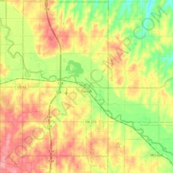
Naam: Topografische kaart Harrah, hoogte, reliëf.
Locatie: Harrah, Oklahoma County, Oklahoma, United States of America (35.42050 -97.23034 35.56635 -97.14076)
Gemiddelde hoogte: 342 m
Minimale hoogte: 294 m
Maximale hoogte: 389 m
Harrah is a small city in Oklahoma with a total land area of 11.9 square miles (31 km2) and no water. The city's elevation is 925 feet (282 m) above sea level. It lies partly in the Great Plains near the geographical center of the 48 contiguous states in the United States. It lies between the larger cities of Oklahoma City to the west and Shawnee, Oklahoma, to the east, in Oklahoma County.