
Topografische kaart Pine Forest Range Wilderness Area
Interactieve kaart
Klik op de kaart om de hoogte weer te geven.
Over deze kaart
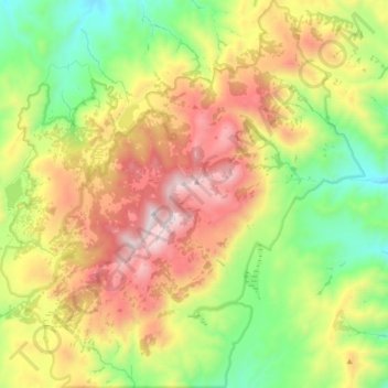
Naam: Topografische kaart Pine Forest Range Wilderness Area, hoogte, reliëf.
Gemiddelde hoogte: 2.083 m
Minimale hoogte: 1.508 m
Maximale hoogte: 2.855 m
Andere topografische kaarten
Klik op een kaart om zijn topografie, zijn hoogte en zijn reliëf te bekijken.
Sonoma Valley
United States > Nevada > Humboldt County
Sonoma Valley, Humboldt County, Nevada, United States
Gemiddelde hoogte: 2.052 m
Paradise Valley
United States > Nevada > Humboldt County
Paradise Valley, Humboldt County, Nevada, 89426, United States
Gemiddelde hoogte: 1.387 m
Golconda
United States > Nevada > Humboldt County
Golconda, Humboldt County, Nevada, 89414, United States
Gemiddelde hoogte: 1.352 m
Winnemucca
United States > Nevada > Humboldt County
Winnemucca, Humboldt County, Nevada, 89445, United States
Gemiddelde hoogte: 1.365 m
Winnemucca
United States > Nevada > Humboldt County > Winnemucca > Winnemucca
Winnemucca, Humboldt County, Nevada, 89445, United States
Gemiddelde hoogte: 1.403 m