
Topografische kaart Oakdale
Interactieve kaart
Klik op de kaart om de hoogte weer te geven.
Over deze kaart
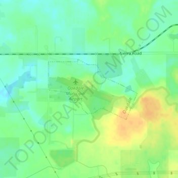
Naam: Topografische kaart Oakdale, hoogte, reliëf.
Locatie: Oakdale, Stanislaus County, California, United States (37.75184 -120.80709 37.76099 -120.79006)
Gemiddelde hoogte: 66 m
Minimale hoogte: 53 m
Maximale hoogte: 81 m
Historically the area has been used for orchards and other agricultural uses. Some of the common soil types found in Oakdale are Delhi sand, Oakdale sandy loam, Hanford sandy loam, and Tujunga loamy sand. Oakdale is generally on level ground at an elevation of approximately 190 feet (58 m) above mean sea level. Drainage is generally to the northwest towards the Stanislaus River.