
Topografische kaart Hamlet of Calahoo
Interactieve kaart
Klik op de kaart om de hoogte weer te geven.
Over deze kaart
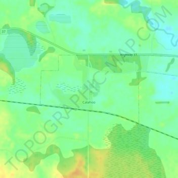
Naam: Topografische kaart Hamlet of Calahoo, hoogte, reliëf.
Locatie: Hamlet of Calahoo, Sturgeon County, Alberta, Canada (53.70533 -113.97141 53.71564 -113.93504)
Gemiddelde hoogte: 683 m
Minimale hoogte: 670 m
Maximale hoogte: 699 m
Andere topografische kaarten
Klik op een kaart om zijn topografie, zijn hoogte en zijn reliëf te bekijken.
Redwater Provincial Recreation Area
Canada > Alberta > Sturgeon County
Redwater Provincial Recreation Area, Township Road 571A, Sturgeon County, Alberta, Canada
Gemiddelde hoogte: 626 m
Hamlet of Lamoureux
Canada > Alberta > Sturgeon County
Hamlet of Lamoureux, Sturgeon County, Alberta, Canada
Gemiddelde hoogte: 621 m
Rivière Qui Barre
Canada > Alberta > Sturgeon County
Rivière Qui Barre, Sturgeon County, Alberta, Canada
Gemiddelde hoogte: 679 m
Hamlet of Rivière Qui Barre
Canada > Alberta > Sturgeon County
Hamlet of Rivière Qui Barre, Sturgeon County, Alberta, Canada
Gemiddelde hoogte: 687 m