
Topografische kaart Half Dome
Interactieve kaart
Klik op de kaart om de hoogte weer te geven.
Over deze kaart
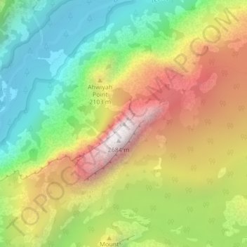
Naam: Topografische kaart Half Dome, hoogte, reliëf.
Locatie: Half Dome, Mariposa County, California, United States (37.74595 -119.53330 37.74605 -119.53320)
Gemiddelde hoogte: 1.887 m
Minimale hoogte: 1.241 m
Maximale hoogte: 2.693 m
The Half Dome Cable Route hike runs from the valley floor to the top of the dome in 8.2 mi (13 km) (via the Mist Trail), with 4,800 ft (1,460 m) of elevation gain. The length and difficulty of the trail used to keep it less crowded than other park trails, but in recent years the trail traffic has grown to as many as 800 people a day. The hike can be done from the valley floor in a single long day, but many people break it up by camping overnight in Little Yosemite Valley. The trail climbs past Vernal Fall and Nevada Fall, then continues into Little Yosemite Valley, then north to the base of the northeast ridge of Half Dome itself.
Andere topografische kaarten
Klik op een kaart om zijn topografie, zijn hoogte en zijn reliëf te bekijken.
Incline
United States > California > Mariposa County
Incline, Mariposa County, California, United States
Gemiddelde hoogte: 795 m
Bear Valley
United States > California > Mariposa County
Bear Valley, Mariposa County, California, United States
Gemiddelde hoogte: 729 m
Smith Peak
United States > California > Mariposa County
Smith Peak, Mariposa County, California, United States
Gemiddelde hoogte: 1.016 m
Guadalupe Mountains
United States > California > Mariposa County
Guadalupe Mountains, Mariposa County, California, United States
Gemiddelde hoogte: 714 m
Mount Bullion
United States > California > Mariposa County
Mount Bullion, Mariposa County, California, United States
Gemiddelde hoogte: 714 m
PO box 577
United States > California > Mariposa County
PO box 577, John Muir Trail, Mariposa County, CAL Fire Southern Region, California, 95389, United States
Gemiddelde hoogte: 1.967 m
Hornitos
United States > California > Mariposa County
Hornitos, Mariposa County, California, 95325, United States
Gemiddelde hoogte: 297 m
Mariposa Grove
United States > California > Mariposa County
Mariposa Grove, Mariposa County, California, United States
Gemiddelde hoogte: 1.809 m
Crane Flat
United States > California > Mariposa County
Crane Flat, Mariposa County, California, United States
Gemiddelde hoogte: 1.906 m
Yosemite Village
United States > California > Mariposa County
Yosemite Village, Mariposa County, California, 95389, United States
Gemiddelde hoogte: 1.680 m
Glacier Point
United States > California > Mariposa County > Curry Village
Glacier Point, PO box 577, Four Mile Trail, Curry Village, Mariposa County, CAL Fire Southern Region, California, 95389, United States
Gemiddelde hoogte: 1.775 m
Wawona
United States > California > Mariposa County
Wawona, Mariposa County, California, United States
Gemiddelde hoogte: 1.334 m