
Topografische kaart Mount Kanlaon Natural Park
Interactieve kaart
Klik op de kaart om de hoogte weer te geven.
Over deze kaart
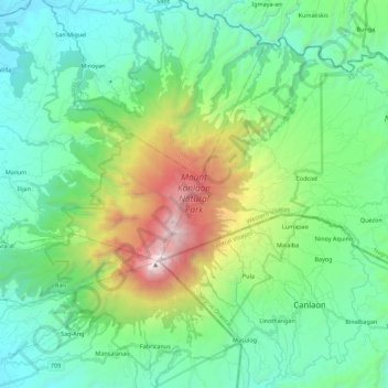
Naam: Topografische kaart Mount Kanlaon Natural Park, hoogte, reliëf.
Gemiddelde hoogte: 650 m
Minimale hoogte: 65 m
Maximale hoogte: 2.426 m
Kanlaon, also known as Mount Kanlaon and Kanlaon Volcano (Hiligaynon: Bolkang Kanglaon; Cebuano: Bolkang Kanglaon; Filipino: Bulkang Kanlaon), is an active stratovolcano and the highest mountain on the island of Negros in the Philippines, as well as the highest point in the Visayas, with an elevation of 2,465 m (8,087 ft) above sea level. Mount Kanlaon ranks as the 42nd-highest peak of an island in the world.
Andere topografische kaarten
Klik op een kaart om zijn topografie, zijn hoogte en zijn reliëf te bekijken.
Mabuni
Philippines > Negros Occidental > San Carlos > Guadalupe
Mabuni, Guadalupe, San Carlos, Negros Occidental, Western Visayas, 6127, Philippines
Gemiddelde hoogte: 26 m
Marabilis
Philippines > Negros Occidental > San Carlos
Marabilis, San Carlos, Negros Occidental, Western Visayas, Philippines
Gemiddelde hoogte: 668 m
Tañon Strait
Philippines > Negros Occidental > San Carlos
Tañon Strait, San Carlos, San Carlos City, Negros Occidental, Western Visayas, Philippines
Gemiddelde hoogte: 0 m
Patag
Philippines > Negros Occidental > San Carlos > Patag
Patag, San Carlos, Negros Occidental, Western Visayas, 6127, Philippines
Gemiddelde hoogte: 105 m
Sipaway Island
Philippines > Negros Occidental > San Carlos
Sipaway Island, San Carlos, Negros Occidental, Western Visayas, Philippines
Gemiddelde hoogte: 1 m
Mt. Mandalagan
Philippines > Negros Occidental > San Carlos
Mt. Mandalagan, San Carlos, Negros Occidental, Western Visayas, Philippines
Gemiddelde hoogte: 1.468 m