Geolokaliseren
👉 Easily get elevation data in JSON, GeoTIFF and KML formats using Elevation API
Bedankt voor het steunen van deze site ❤️
Doe een donatie

Rust jezelf uit voor je volgende avontuur:

Als Amazon-partner verdient deze site een commissie op in aanmerking komende aankopen, zonder extra kosten voor jou.

Topografische kaart Quilcene

Klik op de kaart om de hoogte weer te geven.

Over deze kaart

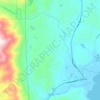
Naam: Topografische kaart Quilcene, hoogte, reliëf.

Locatie: Quilcene, Jefferson County, Washington, United States (47.80672 -122.94356 47.88089 -122.85742)

Gemiddelde hoogte: 116 m

Minimale hoogte: -1 m

Maximale hoogte: 404 m

👉 Easily get elevation data in JSON, GeoTIFF and KML formats using Elevation API
Bedankt voor het steunen van deze site ❤️
Doe een donatie

Rust jezelf uit voor je volgende avontuur:

Als Amazon-partner verdient deze site een commissie op in aanmerking komende aankopen, zonder extra kosten voor jou.

Andere topografische kaarten

Klik op een kaart om zijn topografie, zijn hoogte en zijn reliëf te bekijken.

Duckabush

United States > Washington > Jefferson County

Gemiddelde hoogte: 71 m

Kalaloch

United States > Washington > Jefferson County

Gemiddelde hoogte: 30 m

Mount Olympus

United States > Washington > Jefferson County

With notable local relief, Mount Olympus ascends over 2,100 m (6,900 ft) from the 293 m (961 ft) elevation confluence of the Hoh River with Glacier Creek in only 8.8 km (5.5 mi). Mount Olympus has 2,386 m (7,828 ft) of prominence, ranking 5th in the state of Washington.

Gemiddelde hoogte: 1.934 m

Chimacum

United States > Washington > Jefferson County

Gemiddelde hoogte: 59 m

The Brothers

United States > Washington > Jefferson County

Gemiddelde hoogte: 1.469 m

Mount Olympus

United States > Washington > Jefferson County

With notable local relief, Mount Olympus ascends over 2,100 m (6,900 ft) from the 293 m (961 ft) elevation confluence of the Hoh River with Glacier Creek in only 8.8 km (5.5 mi). Mount Olympus has 2,386 m (7,828 ft) of prominence, ranking 5th in the state of Washington.

Gemiddelde hoogte: 1.934 m

Tukey

United States > Washington > Jefferson County

Gemiddelde hoogte: 34 m

Mount Olympus

United States > Washington > Jefferson County

With notable local relief, Mount Olympus ascends over 2,100 m (6,900 ft) from the 293 m (961 ft) elevation confluence of the Hoh River with Glacier Creek in only 8.8 km (5.5 mi). Mount Olympus has 2,386 m (7,828 ft) of prominence, ranking 5th in the state of Washington.

Gemiddelde hoogte: 1.934 m

Rust jezelf uit voor je volgende avontuur:

🔋Outdoor Powerbanks - Extra energie voor lange outdoor trips
📱Telefoonhouders Fiets - Bevestig je smartphone veilig op je stuur voor navigatie
🗺️Grote Wandkaarten - Decoratieve kaarten voor aan de muur
📏Hoogtemeters - Apparaten om hoogte en stijging te meten
🔋Draagbare Zonnepanelen - Laad je apparaten op met zonne-energie

Als Amazon-partner verdient deze site een commissie op in aanmerking komende aankopen, zonder extra kosten voor jou.