
Topografische kaart Xinping Yi and Dai Autonomous County
Interactieve kaart
Klik op de kaart om de hoogte weer te geven.
Over deze kaart
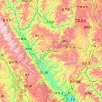
Naam: Topografische kaart Xinping Yi and Dai Autonomous County, hoogte, reliëf.
Locatie: Xinping Yi and Dai Autonomous County, Yuxi, Yunnan, China (23.63533 101.27532 24.43172 102.28219)
Gemiddelde hoogte: 1.502 m
Minimale hoogte: 377 m
Maximale hoogte: 3.128 m
Andere topografische kaarten
Klik op een kaart om zijn topografie, zijn hoogte en zijn reliëf te bekijken.