
Doe een donatie
Rust jezelf uit voor je volgende avontuur:
Als Amazon-partner verdient deze site een commissie op in aanmerking komende aankopen, zonder extra kosten voor jou.
Topografische kaart Bricquebec
Klik op de kaart om de hoogte weer te geven.
Doe een donatie
Rust jezelf uit voor je volgende avontuur:
Als Amazon-partner verdient deze site een commissie op in aanmerking komende aankopen, zonder extra kosten voor jou.
Over deze kaart
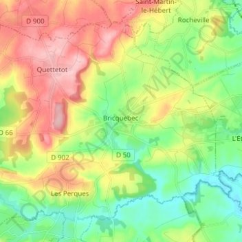
Naam: Topografische kaart Bricquebec, hoogte, reliëf.
Gemiddelde hoogte: 71 m
Minimale hoogte: 6 m
Maximale hoogte: 163 m
Doe een donatie
Rust jezelf uit voor je volgende avontuur:
Als Amazon-partner verdient deze site een commissie op in aanmerking komende aankopen, zonder extra kosten voor jou.
Andere topografische kaarten
Klik op een kaart om zijn topografie, zijn hoogte en zijn reliëf te bekijken.
La Pasquerie
France > Normandie > Manche > Bricquebec-en-Cotentin > Quettetot
Gemiddelde hoogte: 112 m
Doe een donatie
Rust jezelf uit voor je volgende avontuur:
Als Amazon-partner verdient deze site een commissie op in aanmerking komende aankopen, zonder extra kosten voor jou.
Hameau Giot
France > Normandie > Manche > Bricquebec-en-Cotentin > Les Perques > Hameau Giot
Gemiddelde hoogte: 57 m
Catigny
France > Normandie > Manche > Bricquebec-en-Cotentin > Bricquebec > Catigny
Gemiddelde hoogte: 104 m
La Croix Blanche
France > Normandie > Manche > Bricquebec-en-Cotentin > Bricquebec
Gemiddelde hoogte: 89 m
Doe een donatie
Rust jezelf uit voor je volgende avontuur:
Als Amazon-partner verdient deze site een commissie op in aanmerking komende aankopen, zonder extra kosten voor jou.
Hameau es Cavelier
France > Normandie > Manche > Bricquebec-en-Cotentin > Quettetot
Gemiddelde hoogte: 113 m
Hameau Val Fontaine
France > Normandie > Manche > Bricquebec-en-Cotentin > Les Perques
Gemiddelde hoogte: 66 m