
Topografische kaart Big Pine
Interactieve kaart
Klik op de kaart om de hoogte weer te geven.
Over deze kaart
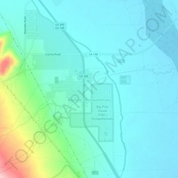
Naam: Topografische kaart Big Pine, hoogte, reliëf.
Locatie: Big Pine, Inyo County, California, 92513, United States (37.14283 -118.31490 37.18673 -118.27680)
Gemiddelde hoogte: 1.228 m
Minimale hoogte: 1.192 m
Maximale hoogte: 1.391 m
Big Pine (formerly, Bigpine) is a census-designated place (CDP) in Inyo County, California, United States. Big Pine is located approximately 15 miles (24 km) south-southeast of Bishop, at an elevation of 3,989 feet (1,216 m). The population was 1,756 at the 2010 census, up from 1,350 at the 2000 census. The Big Pine Band of Owens Valley Paiute Shoshone Indians of the Big Pine Reservation operates their tribal headquarters from here.
Andere topografische kaarten
Klik op een kaart om zijn topografie, zijn hoogte en zijn reliëf te bekijken.
Big Pine Creek
United States > California > Inyo County > Big Pine
Big Pine Creek, Big Pine, Inyo County, California, 92513, United States
Gemiddelde hoogte: 1.210 m