
Doe een donatie
Rust jezelf uit voor je volgende avontuur:
Als Amazon-partner verdient deze site een commissie op in aanmerking komende aankopen, zonder extra kosten voor jou.
Topografische kaart Les Gatillons
Klik op de kaart om de hoogte weer te geven.
Doe een donatie
Rust jezelf uit voor je volgende avontuur:
Als Amazon-partner verdient deze site een commissie op in aanmerking komende aankopen, zonder extra kosten voor jou.
Over deze kaart
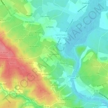
Naam: Topografische kaart Les Gatillons, hoogte, reliëf.
Gemiddelde hoogte: 42 m
Minimale hoogte: 7 m
Maximale hoogte: 105 m
Doe een donatie
Rust jezelf uit voor je volgende avontuur:
Als Amazon-partner verdient deze site een commissie op in aanmerking komende aankopen, zonder extra kosten voor jou.
Andere topografische kaarten
Klik op een kaart om zijn topografie, zijn hoogte en zijn reliëf te bekijken.
Cherves-Richemont
France > Nouvelle-Aquitaine > Charente > Val-de-Cognac
La moitié nord de la commune est occupée par la plaine du pays bas, d'une altitude moyenne de 25 m et 10 m dans ses parties les plus basses.
Gemiddelde hoogte: 25 m
Saint-Sulpice-de-Cognac
France > Nouvelle-Aquitaine > Charente > Val-de-Cognac
Hormis le tiers nord-est de la commune, le relief est assez vallonné et relativement haut. Le point culminant est à une altitude de 104 m, situé à 2 km à l'ouest du bourg, près de chez Tachet. Le point le plus bas est à 10 m, situé en limite sud-est le long de l'Antenne. Le bourg, situé au bord de…
Gemiddelde hoogte: 52 m