
Topografische kaart Kamand
Interactieve kaart
Klik op de kaart om de hoogte weer te geven.
Over deze kaart
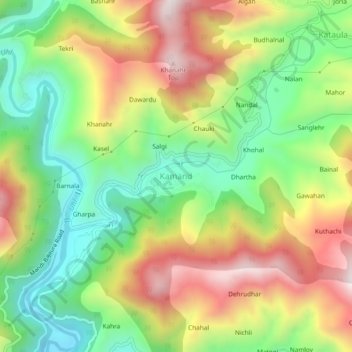
Naam: Topografische kaart Kamand, hoogte, reliëf.
Locatie: Kamand, Mandi, Himachal Pradesh, 175075, India (31.76172 76.97736 31.80172 77.01736)
Gemiddelde hoogte: 1.259 m
Minimale hoogte: 938 m
Maximale hoogte: 1.666 m
Andere topografische kaarten
Klik op een kaart om zijn topografie, zijn hoogte en zijn reliëf te bekijken.
Mandi
India > Himachal Pradesh > Mandi
Mandi, Mandi District, Himachal Pradesh, 175001, India
Gemiddelde hoogte: 1.273 m
Nerchowk
India > Himachal Pradesh > Mandi
Nerchowk, Mandi, Mandi District, Himachal Pradesh, 175008, India
Gemiddelde hoogte: 843 m
Beas River
India > Himachal Pradesh > Mandi > Pandoh
Beas River, Pandoh, Mandi, Himachal Pradesh, 175124, India
Gemiddelde hoogte: 962 m
Rewalsar
India > Himachal Pradesh > Mandi
Rewalsar, Mandi, Mandi District, Himachal Pradesh, 175023, India
Gemiddelde hoogte: 1.283 m