
Doe een donatie
Rust jezelf uit voor je volgende avontuur:
Als Amazon-partner verdient deze site een commissie op in aanmerking komende aankopen, zonder extra kosten voor jou.
Topografische kaart Belvidere
Klik op de kaart om de hoogte weer te geven.
Doe een donatie
Rust jezelf uit voor je volgende avontuur:
Als Amazon-partner verdient deze site een commissie op in aanmerking komende aankopen, zonder extra kosten voor jou.
Belvidere
Belvidere developed on both sides of the Kishwaukee River in north central Illinois. It is 76 miles from downtown Chicago on Routes 20, 76 and the Northern Illinois Toll road. Belvidere is an industrial community surrounded by prosperous farms. It is the County Seat with an estimated 2006 county population of over 52,000. The altitude is 800 feet above sea level, average temperatures are: 73 degrees F in the summer; 24 degrees F in the winter, and the average rainfall is 33.3 inches, and the average annual snowfall is 35.3 inches.
Doe een donatie
Rust jezelf uit voor je volgende avontuur:
Als Amazon-partner verdient deze site een commissie op in aanmerking komende aankopen, zonder extra kosten voor jou.
Over deze kaart
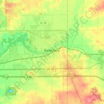
Naam: Topografische kaart Belvidere, hoogte, reliëf.
Gemiddelde hoogte: 244 m
Minimale hoogte: 208 m
Maximale hoogte: 282 m
Doe een donatie
Rust jezelf uit voor je volgende avontuur:
Als Amazon-partner verdient deze site een commissie op in aanmerking komende aankopen, zonder extra kosten voor jou.
Andere topografische kaarten
Klik op een kaart om zijn topografie, zijn hoogte en zijn reliëf te bekijken.