
Topografische kaart The Cells State Conservation Area
Interactieve kaart
Klik op de kaart om de hoogte weer te geven.
Over deze kaart
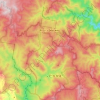
Naam: Topografische kaart The Cells State Conservation Area, hoogte, reliëf.
Gemiddelde hoogte: 724 m
Minimale hoogte: 279 m
Maximale hoogte: 1.069 m
Andere topografische kaarten
Klik op een kaart om zijn topografie, zijn hoogte en zijn reliëf te bekijken.
Mount Seaview
Australia > New South Wales > Mount Seaview
Mount Seaview, Port Macquarie-Hastings Council, New South Wales, 2446, Australia
Gemiddelde hoogte: 725 m
Gingers Creek
Australia > New South Wales > Mount Seaview
Gingers Creek, Mount Seaview, Port Macquarie-Hastings Council, New South Wales, Australia
Gemiddelde hoogte: 719 m