
Topografische kaart Macroom
Interactieve kaart
Klik op de kaart om de hoogte weer te geven.
Over deze kaart
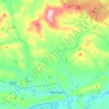
Naam: Topografische kaart Macroom, hoogte, reliëf.
Gemiddelde hoogte: 210 m
Minimale hoogte: 47 m
Maximale hoogte: 642 m
Andere topografische kaarten
Klik op een kaart om zijn topografie, zijn hoogte en zijn reliëf te bekijken.
Kilnamartery
Ireland > County Cork > Municipal District of Macroom
Kilnamartery, Municipal District of Macroom, County Cork, Munster, Ireland
Gemiddelde hoogte: 118 m
Iniscarra Dam View
Ireland > County Cork > Municipal District of Macroom
Iniscarra Dam View, L5228, Ovens, Municipal District of Macroom, County Cork, Munster, P31 TX39, Ireland
Gemiddelde hoogte: 83 m
Monallig
Ireland > County Cork > Municipal District of Macroom
Monallig, Cannaway ED, Municipal District of Macroom, County Cork, Munster, Ireland
Gemiddelde hoogte: 90 m
Drominahilla
Ireland > County Cork > Municipal District of Macroom
Drominahilla, Drishane, Municipal District of Macroom, County Cork, Munster, Ireland
Gemiddelde hoogte: 127 m
Loughane East
Ireland > County Cork > Municipal District of Macroom
Loughane East, Matehy, Municipal District of Macroom, County Cork, Munster, Ireland
Gemiddelde hoogte: 98 m
Donoughmore
Ireland > County Cork > Municipal District of Macroom
Donoughmore, Municipal District of Macroom, County Cork, Munster, Ireland
Gemiddelde hoogte: 183 m