
Topografische kaart Mount Magazine State Park
Interactieve kaart
Klik op de kaart om de hoogte weer te geven.
Over deze kaart
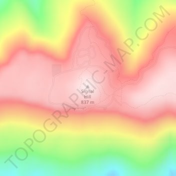
Naam: Topografische kaart Mount Magazine State Park, hoogte, reliëf.
Gemiddelde hoogte: 667 m
Minimale hoogte: 373 m
Maximale hoogte: 839 m
There also exist many opportunities for ATV riding, backpacking, hang gliding, mountain biking, rappelling, and rock climbing within the park. The park hosts the annual Mount Magazine International Butterfly Festival, and is a haven for many rare species of butterflies in Arkansas due to the special blend of altitude and temperature available. The state butterfly, the Diana fritillary, is found almost exclusively in the Arkansas River Valley and the Petit Jean River Valley.
Andere topografische kaarten
Klik op een kaart om zijn topografie, zijn hoogte en zijn reliëf te bekijken.
Booneville
United States > Arkansas > Logan County
Booneville, Logan County, Arkansas, 72927, United States
Gemiddelde hoogte: 153 m
Saint Scholastica
United States > Arkansas > Logan County
Saint Scholastica, Logan County, Arkansas, 72851, United States
Gemiddelde hoogte: 142 m
Driggs
United States > Arkansas > Logan County
Driggs, Logan County, Arkansas, United States
Gemiddelde hoogte: 227 m
Paris
United States > Arkansas > Logan County
Paris, Logan County, Arkansas, 72855, United States
Gemiddelde hoogte: 165 m