
Topografische kaart Malaspina Glacier
Interactieve kaart
Klik op de kaart om de hoogte weer te geven.
Malaspina Glacier
The Malaspina is up to 600 meters (2,000 ft) thick in places, with the elevation of its bottom being estimated to be as much as 300 m (980 ft) below sea level.[4] There are two lakes on its margins: Oily Lake to the northwest, at the foot of the Samovar Hills between the Agassiz and Seward glaciers, and Malaspina Lake to the southeast, close to Yakutat Bay.
Over deze kaart
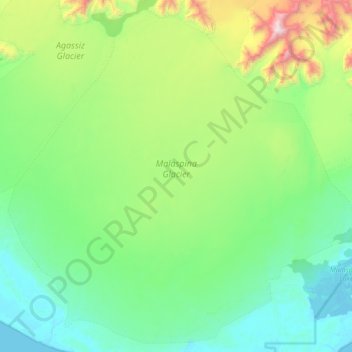
Naam: Topografische kaart Malaspina Glacier, hoogte, reliëf.
Locatie: Malaspina Glacier, Yakutat, Alaska, United States (59.74222 -140.95854 60.13048 -140.14049)
Gemiddelde hoogte: 393 m
Minimale hoogte: -3 m
Maximale hoogte: 2.086 m
Andere topografische kaarten
Klik op een kaart om zijn topografie, zijn hoogte en zijn reliëf te bekijken.
Hubbard Glacier
United States > Alaska > Yakutat
The longest source for Hubbard Glacier originates 122 kilometres (76 mi) from its snout and is located at about 61°00′N 140°09′W / 61.000°N 140.150°W / 61.000; -140.150, approximately 8 kilometres (5 mi) west of Mount Walsh with an elevation around 3,400 metres (11,200 ft). A shorter tributary…
Gemiddelde hoogte: 1.892 m