
Topografische kaart Mactan
Interactieve kaart
Klik op de kaart om de hoogte weer te geven.
Over deze kaart
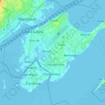
Naam: Topografische kaart Mactan, hoogte, reliëf.
Locatie: Mactan, Lapu-Lapu, Cebu, Central Visayas, Philippines (10.24226 123.92292 10.33429 124.04565)
Gemiddelde hoogte: 3 m
Minimale hoogte: -3 m
Maximale hoogte: 55 m
Andere topografische kaarten
Klik op een kaart om zijn topografie, zijn hoogte en zijn reliëf te bekijken.
Olango Island
Philippines > Cebu > Lapu-Lapu
Olango Island, Lapu-Lapu, Cebu, Central Visayas, Philippines
Gemiddelde hoogte: 2 m
Sulpa Islet
Philippines > Cebu > Lapu-Lapu
Sulpa Islet, Lapu-Lapu, Cebu, Central Visayas, Philippines
Gemiddelde hoogte: 0 m
Hilutungan Sanctuary
Philippines > Cebu > Lapu-Lapu
Hilutungan Sanctuary, Simean Amodia, Pacific Grand Villas, Lapu-Lapu, Cebu, Central Visayas, 6017, Philippines
Gemiddelde hoogte: 0 m
Gilutongan Island
Philippines > Cebu > Lapu-Lapu
Gilutongan Island, Lapu-Lapu, Cebu, Central Visayas, Philippines
Gemiddelde hoogte: 0 m