
Topografische kaart Klamath Falls
Interactieve kaart
Klik op de kaart om de hoogte weer te geven.
Klamath Falls
According to the United States Census Bureau, the city has a total area of 20.66 square miles (53.51 km2), of which 19.81 square miles (51.31 km2) is land and 0.85 square miles (2.20 km2) is water. The elevation is 4,094 feet (1,248 m).
Over deze kaart
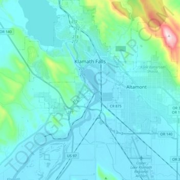
Naam: Topografische kaart Klamath Falls, hoogte, reliëf.
Gemiddelde hoogte: 1.312 m
Minimale hoogte: 1.240 m
Maximale hoogte: 1.887 m
Andere topografische kaarten
Klik op een kaart om zijn topografie, zijn hoogte en zijn reliëf te bekijken.
Mount Scott
United States > Oregon > Klamath County
There is one trail to the summit of Mount Scott. Starting on Rim Drive, the trail is about 2.5 miles (4.0 km) long. It has many switchbacks, and ends at the fire lookout tower on the summit. The trailhead is at an elevation of 7,683 feet (2,342 m), and the trail climbs approximately 1,479 feet (451 m) to the…
Gemiddelde hoogte: 2.295 m