
Doe een donatie
Rust jezelf uit voor je volgende avontuur:
Als Amazon-partner verdient deze site een commissie op in aanmerking komende aankopen, zonder extra kosten voor jou.
Topografische kaart Ball Ground
Klik op de kaart om de hoogte weer te geven.
Doe een donatie
Rust jezelf uit voor je volgende avontuur:
Als Amazon-partner verdient deze site een commissie op in aanmerking komende aankopen, zonder extra kosten voor jou.
Ball Ground
According to the United States Census Bureau as of 2020, Ball Ground has a total area of 6.3 sq mi (16 km2), of which 0.04 sq mi (0.10 km2), or 0.63%, is water. The city's elevation averages around 1,100 ft (340 m) above sea level, ranging from just over 1,000 ft (300 m) in the valleys to around 1,200 ft (370 m) on several hilltops within the city. Unlike most other parts of Cherokee County, Ball Ground is not in a floodplain and has no typically flood prone areas. To protect the water and surrounding lands, the city government has ordinances in place for stream buffer protection, watershed protection, and wetland protection.
Doe een donatie
Rust jezelf uit voor je volgende avontuur:
Als Amazon-partner verdient deze site een commissie op in aanmerking komende aankopen, zonder extra kosten voor jou.
Over deze kaart
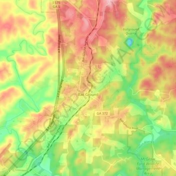
Naam: Topografische kaart Ball Ground, hoogte, reliëf.
Locatie: Ball Ground, Cherokee County, Georgia, United States (34.31118 -84.41254 34.37075 -84.32178)
Gemiddelde hoogte: 331 m
Minimale hoogte: 243 m
Maximale hoogte: 414 m
Doe een donatie
Rust jezelf uit voor je volgende avontuur:
Als Amazon-partner verdient deze site een commissie op in aanmerking komende aankopen, zonder extra kosten voor jou.
Andere topografische kaarten
Klik op een kaart om zijn topografie, zijn hoogte en zijn reliëf te bekijken.
Doe een donatie
Rust jezelf uit voor je volgende avontuur:
Als Amazon-partner verdient deze site een commissie op in aanmerking komende aankopen, zonder extra kosten voor jou.
Doe een donatie
Rust jezelf uit voor je volgende avontuur:
Als Amazon-partner verdient deze site een commissie op in aanmerking komende aankopen, zonder extra kosten voor jou.