
Topografische kaart Bavarian Forest National Park
Interactieve kaart
Klik op de kaart om de hoogte weer te geven.
Bavarian Forest National Park
Especially protected are the Norway spruce–dominated highland forests, mixed mountain forests of European silver fir, European beech and spruce trees and water meadow spruce woods in the valleys. Although a few remnants of ancient forest remain, the National Park area is still heavily influenced by the former forestry industry. Since nature is now left to take its course again, there is no human intervention when there are catastrophic events such as large scale bark beetle infestation. This resulted in the death of a portion of the high elevation forests in the 1990s and triggered controversial discussions amongst the residents of the National Park, which highlighted differing attitudes to the wilderness. As the result of a compromise, bark beetle is now fought in the buffer area.
Over deze kaart
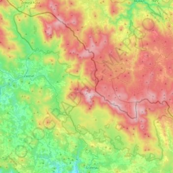
Naam: Topografische kaart Bavarian Forest National Park, hoogte, reliëf.
Gemiddelde hoogte: 870 m
Minimale hoogte: 453 m
Maximale hoogte: 1.435 m
Andere topografische kaarten
Klik op een kaart om zijn topografie, zijn hoogte en zijn reliëf te bekijken.
Großer Arber
Germany > Bavaria > Landkreis Regen > Bayerisch Eisenstein
The Großer Arber (German pronunciation); Czech: Velký Javor, "Great Maple") or Great Arber, is the highest peak of the Bavarian/Bohemian Forest mountain range and in Lower Bavaria, with an elevation of 1,455.5 metres (4,775 ft). As a result, it is known in the Lower Bavarian county of Regen and the Upper…
Gemiddelde hoogte: 1.141 m