
Topografische kaart Fanling
Interactieve kaart
Klik op de kaart om de hoogte weer te geven.
Over deze kaart
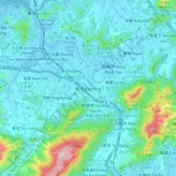
Naam: Topografische kaart Fanling, hoogte, reliëf.
Locatie: Fanling, North District, New Territories, Hong Kong, China (22.45463 114.09827 22.53463 114.17827)
Gemiddelde hoogte: 73 m
Minimale hoogte: -2 m
Maximale hoogte: 477 m
Andere topografische kaarten
Klik op een kaart om zijn topografie, zijn hoogte en zijn reliëf te bekijken.
Ping Che
China > Hong Kong > North District
Ping Che, North District, New Territories, Hong Kong, 518021, China
Gemiddelde hoogte: 41 m
黃崗山 Wong Kong Shan
China > Hong Kong > North District > Fanling
黃崗山 Wong Kong Shan, Fanling, North District, New Territories, Hong Kong, China
Gemiddelde hoogte: 68 m
Kidney Hill
China > Hong Kong > North District
Kidney Hill, North District, New Territories, Hong Kong, 518032, China
Gemiddelde hoogte: 27 m
Shung Him Tong Tsuen
China > Hong Kong > North District > Lo Wai
Shung Him Tong Tsuen, Lo Wai, North District, New Territories, Hong Kong, China
Gemiddelde hoogte: 58 m
Sheung Shui
China > Hong Kong > North District
Sheung Shui, North District, New Territories, Hong Kong, 518005, China
Gemiddelde hoogte: 64 m
Ma Liu Shui San Tsuen
China > Hong Kong > North District > Queen's Hill
Ma Liu Shui San Tsuen, Queen's Hill, North District, New Territories, Hong Kong, China
Gemiddelde hoogte: 54 m