Topografische kaart Curiscada
Interactieve kaart
Klik op de kaart om de hoogte weer te geven.
Over deze kaart
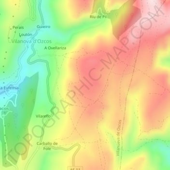
Naam: Topografische kaart Curiscada, hoogte, reliëf.
Gemiddelde hoogte: 790 m
Minimale hoogte: 606 m
Maximale hoogte: 954 m

Klik op de kaart om de hoogte weer te geven.
Naam: Topografische kaart Curiscada, hoogte, reliëf.
Gemiddelde hoogte: 790 m
Minimale hoogte: 606 m
Maximale hoogte: 954 m