
Topografische kaart Kofa National Wildlife Refuge
Interactieve kaart
Klik op de kaart om de hoogte weer te geven.
Over deze kaart
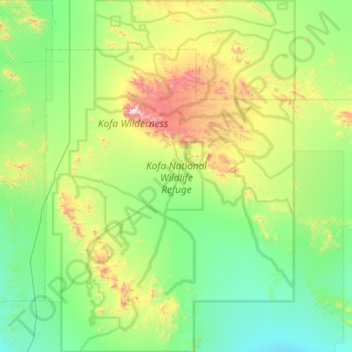
Naam: Topografische kaart Kofa National Wildlife Refuge, hoogte, reliëf.
Gemiddelde hoogte: 460 m
Minimale hoogte: 151 m
Maximale hoogte: 1.439 m
Andere topografische kaarten
Klik op een kaart om zijn topografie, zijn hoogte en zijn reliëf te bekijken.
San Luis
United States > Arizona > Yuma County
San Luis, Yuma County, Arizona, United States
Gemiddelde hoogte: 36 m
Araby
United States > Arizona > Yuma County > Yuma
Araby, Yuma, Yuma County, Arizona, 85365, United States
Gemiddelde hoogte: 60 m
Palomas
United States > Arizona > Yuma County
Palomas, Yuma County, Arizona, United States
Gemiddelde hoogte: 125 m
Hyder
United States > Arizona > Yuma County
Hyder, Yuma County, Arizona, 85333, United States
Gemiddelde hoogte: 173 m
Dateland
United States > Arizona > Yuma County
Dateland, Yuma County, Arizona, United States
Gemiddelde hoogte: 138 m
Somerton
United States > Arizona > Yuma County
Somerton, Yuma County, Arizona, 85350, United States
Gemiddelde hoogte: 33 m
Buckshot
United States > Arizona > Yuma County
Buckshot, Yuma County, Arizona, United States
Gemiddelde hoogte: 52 m
Fortuna Foothills
United States > Arizona > Yuma County
Fortuna Foothills, Yuma County, Arizona, United States
Gemiddelde hoogte: 133 m
Yuma
United States > Arizona > Yuma County
Yuma, Yuma County, Arizona, United States
Gemiddelde hoogte: 78 m
Noah
United States > Arizona > Yuma County
Noah, Yuma County, Arizona, United States
Gemiddelde hoogte: 106 m
Tuscan Ranch
United States > Arizona > Yuma County > Yuma
Tuscan Ranch, Yuma, Yuma County, Arizona, United States
Gemiddelde hoogte: 63 m
Wellton
United States > Arizona > Yuma County
Wellton, Yuma County, Arizona, United States
Gemiddelde hoogte: 97 m
Laguna Mountains
United States > Arizona > Yuma County
Laguna Mountains, Yuma County, Arizona, United States
Gemiddelde hoogte: 141 m