
Doe een donatie
Rust jezelf uit voor je volgende avontuur:
Als Amazon-partner verdient deze site een commissie op in aanmerking komende aankopen, zonder extra kosten voor jou.
Topografische kaart Weißensee
Klik op de kaart om de hoogte weer te geven.
Doe een donatie
Rust jezelf uit voor je volgende avontuur:
Als Amazon-partner verdient deze site een commissie op in aanmerking komende aankopen, zonder extra kosten voor jou.
Over deze kaart
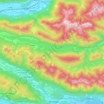
Naam: Topografische kaart Weißensee, hoogte, reliëf.
Gemiddelde hoogte: 1.191 m
Minimale hoogte: 556 m
Maximale hoogte: 2.210 m
Doe een donatie
Rust jezelf uit voor je volgende avontuur:
Als Amazon-partner verdient deze site een commissie op in aanmerking komende aankopen, zonder extra kosten voor jou.
Andere topografische kaarten
Klik op een kaart om zijn topografie, zijn hoogte en zijn reliëf te bekijken.
Großglockner
Austria > Carinthia > Bezirk Spittal an der Drau > Heiligenblut am Großglockner
The Glockner is the highest mountain in the Alps east of the Ortler range, about 175 km (109 mi) away, and, after Mont Blanc, has the second greatest topographic isolation of all mountains in the Alps. Even its topographic prominence, at 2,424 m (7,953 ft), is the second highest after Mont Blanc in the entire…
Gemiddelde hoogte: 3.128 m
Freier Seezugang Millstätter See bei Spittal an der Drau, Großegg
Austria > Carinthia > Bezirk Spittal an der Drau > Spittal an der Drau
Gemiddelde hoogte: 677 m
Pasterze
Austria > Carinthia > Bezirk Spittal an der Drau > Heiligenblut am Großglockner
Gemiddelde hoogte: 2.599 m
Sankt Wolfgang
Austria > Carinthia > Bezirk Spittal an der Drau > Seeboden am Millstätter See > Seebach
Gemiddelde hoogte: 626 m
Doe een donatie
Rust jezelf uit voor je volgende avontuur:
Als Amazon-partner verdient deze site een commissie op in aanmerking komende aankopen, zonder extra kosten voor jou.
Untertauern
Austria > Carinthia > Bezirk Spittal an der Drau > Heiligenblut am Großglockner
Gemiddelde hoogte: 1.682 m
Großglockner
Austria > Carinthia > Bezirk Spittal an der Drau > Heiligenblut am Großglockner
The Glockner is the highest mountain in the Alps east of the Ortler range, about 175 km (109 mi) away, and, after Mont Blanc, has the second greatest topographic isolation of all mountains in the Alps. Even its topographic prominence, at 2,424 m (7,953 ft), is the second highest after Mont Blanc in the entire…
Gemiddelde hoogte: 3.128 m
Doe een donatie
Rust jezelf uit voor je volgende avontuur:
Als Amazon-partner verdient deze site een commissie op in aanmerking komende aankopen, zonder extra kosten voor jou.
Doe een donatie
Rust jezelf uit voor je volgende avontuur:
Als Amazon-partner verdient deze site een commissie op in aanmerking komende aankopen, zonder extra kosten voor jou.
Tangern
Austria > Carinthia > Bezirk Spittal an der Drau > Spittal an der Drau
Gemiddelde hoogte: 691 m
Falkert
Austria > Carinthia > Bezirk Spittal an der Drau > Bad Kleinkirchheim
Gemiddelde hoogte: 2.023 m
Großglockner
Austria > Carinthia > Bezirk Spittal an der Drau > Heiligenblut am Großglockner
The Glockner is the highest mountain in the Alps east of the Ortler range, about 175 km (109 mi) away, and, after Mont Blanc, has the second greatest topographic isolation of all mountains in the Alps. Even its topographic prominence, at 2,424 m (7,953 ft), is the second highest after Mont Blanc in the entire…
Gemiddelde hoogte: 3.128 m
Doe een donatie
Rust jezelf uit voor je volgende avontuur:
Als Amazon-partner verdient deze site een commissie op in aanmerking komende aankopen, zonder extra kosten voor jou.
Großglockner
Austria > Carinthia > Bezirk Spittal an der Drau > Heiligenblut am Großglockner
The Glockner is the highest mountain in the Alps east of the Ortler range, about 175 km (109 mi) away, and, after Mont Blanc, has the second greatest topographic isolation of all mountains in the Alps. Even its topographic prominence, at 2,424 m (7,953 ft), is the second highest after Mont Blanc in the entire…
Gemiddelde hoogte: 3.128 m
Rothorn
Austria > Carinthia > Bezirk Spittal an der Drau > Dellach im Drautal
Gemiddelde hoogte: 2.299 m
Doe een donatie
Rust jezelf uit voor je volgende avontuur:
Als Amazon-partner verdient deze site een commissie op in aanmerking komende aankopen, zonder extra kosten voor jou.
Heiligenblut
Austria > Carinthia > Bezirk Spittal an der Drau > Heiligenblut am Großglockner
Gemiddelde hoogte: 1.982 m
Doe een donatie
Rust jezelf uit voor je volgende avontuur:
Als Amazon-partner verdient deze site een commissie op in aanmerking komende aankopen, zonder extra kosten voor jou.
Maltatal
Austria > Carinthia > Bezirk Spittal an der Drau > Gmünd in Kärnten
Gemiddelde hoogte: 1.914 m
Hadergasse
Austria > Carinthia > Bezirk Spittal an der Drau > Heiligenblut am Großglockner
Gemiddelde hoogte: 1.677 m