
Topografische kaart Kuopio
Interactieve kaart
Klik op de kaart om de hoogte weer te geven.
Over deze kaart
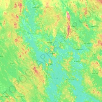
Naam: Topografische kaart Kuopio, hoogte, reliëf.
Gemiddelde hoogte: 116 m
Minimale hoogte: 75 m
Maximale hoogte: 308 m
Andere topografische kaarten
Klik op een kaart om zijn topografie, zijn hoogte en zijn reliëf te bekijken.
Tahko
Finland > North Savo > Kuopio
Tahko, Kuopio, Kuopio sub-region, North Savo, Regional State Administrative Agency for Eastern Finland, Mainland Finland, 73310, Finland
Gemiddelde hoogte: 144 m
Vesanto
Vesanto, Inner Savonia, North Savo, Regional State Administrative Agency for Eastern Finland, Mainland Finland, 72300, Finland
Gemiddelde hoogte: 116 m
Varkaus
Varkaus, Varkaus sub-region, North Savo, Regional State Administrative Agency for Eastern Finland, Mainland Finland, Finland
Gemiddelde hoogte: 100 m
North Eastern Savonia
North Eastern Savonia, North Savo, Regional State Administrative Agency for Eastern Finland, Mainland Finland, Finland
Gemiddelde hoogte: 130 m
Rönö
Finland > North Savo > Kuopio
Rönö, Kuopio, Kuopio sub-region, North Savo, Regional State Administrative Agency for Eastern Finland, Mainland Finland, Finland
Gemiddelde hoogte: 81 m
Kuopio
Finland > North Savo > Kuopio
Kuopio, Kuopio sub-region, North Savo, Regional State Administrative Agency for Eastern Finland, Mainland Finland, Finland
Gemiddelde hoogte: 109 m