
Topografische kaart Siġġiewi
Interactieve kaart
Klik op de kaart om de hoogte weer te geven.
Over deze kaart
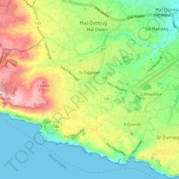
Naam: Topografische kaart Siġġiewi, hoogte, reliëf.
Locatie: Siġġiewi, Southern Region, Malta (35.82602 14.38956 35.86856 14.47248)
Gemiddelde hoogte: 93 m
Minimale hoogte: 0 m
Maximale hoogte: 250 m
In its demographic and topographical formation, Siġġiewi followed a pattern common to other villages in Malta. Before the arrival of the Order of St John in 1530, there were other thriving hamlets in the area. Little by little, Ħal Xluq, Ħal Kbir, Ħal Niklusi, and Ħal Qdieri were absorbed in Siġġiewi and today only their secluded chapels remain.
Andere topografische kaarten
Klik op een kaart om zijn topografie, zijn hoogte en zijn reliëf te bekijken.
Malta
Malta, Southern Region, Sovereign Military Hospitaller Order of Saint John of Jerusalem, of Rhodes and of Malta, Malta
Gemiddelde hoogte: 37 m
Filfla
Malta > Southern Region > Żurrieq
Filfla, Żurrieq, Southern Region, Malta
Gemiddelde hoogte: 0 m
Blue Grotto
Malta > Southern Region > Żurrieq
Blue Grotto, Triq il-Wied, Żurrieq, Southern Region, QRD 3043, Malta
Gemiddelde hoogte: 61 m