
Topografische kaart Morningside Park
Interactieve kaart
Klik op de kaart om de hoogte weer te geven.
Over deze kaart
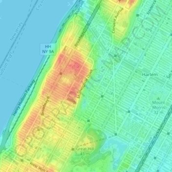
Naam: Topografische kaart Morningside Park, hoogte, reliëf.
Gemiddelde hoogte: 20 m
Minimale hoogte: 0 m
Maximale hoogte: 61 m
Dutch settlers occupied Manhattan in the early 17th century and called the area around Morningside Park Vredendal, meaning 'peaceful dale'. The lowlands to the east were called Flacken by the Dutch, and were later translated to "Flats" in English. The land to the east was not settled initially because of its marshy topography. The area became known as Montagne's (or Montayne's) Flat after Johannes de la Montagne, who was among the first European settlers of New Harlem in 1658; he owned about 200 acres (81 ha) between what is now 109th and 124th Streets. The western boundary of the area was the cliff, while the eastern boundary was a creek that emptied east into the East River. Montagne's Flat was subdivided into lots in 1662, and four years later a new charter for New Harlem was given to the English, who had seized New Netherland, renaming it New York. Through the 17th and 18th centuries, the cliff formed a geopolitical boundary between Harlem to the east and the heights to the west.
Andere topografische kaarten
Klik op een kaart om zijn topografie, zijn hoogte en zijn reliëf te bekijken.
Manhattan
United States > New York > New York County > New York
Manhattan, New York County, New York, United States
Gemiddelde hoogte: 16 m
Central Park
United States > New York > New York County > New York
Central Park, New York County, New York, United States
Gemiddelde hoogte: 26 m
Roosevelt Island
United States > New York > New York County > New York
Roosevelt Island, Manhattan, New York County, New York, 10044, United States
Gemiddelde hoogte: 13 m
Battery Park
United States > New York > New York County > New York
Battery Park, Manhattan Community Board 1, Manhattan, New York County, New York, 10004, United States
Gemiddelde hoogte: 3 m
Sara D. Roosevelt Park
United States > New York > New York County > New York
Sara D. Roosevelt Park, Lower East Side, Manhattan, New York County, New York, United States
Gemiddelde hoogte: 14 m
Brooklyn Bridge Park
United States > New York > New York County > New York
Brooklyn Bridge Park, Kings County, New York County, New York, 11201, United States
Gemiddelde hoogte: 9 m
Paley Park
United States > New York > New York County > New York
Paley Park, Midtown East, Manhattan, New York County, New York, 10022, United States
Gemiddelde hoogte: 24 m
Liberty Island
United States > New York > New York County > New York
Liberty Island, Manhattan Community Board 1, Manhattan, New York County, New York, Hudson County, New York, United States
Gemiddelde hoogte: 0 m
Fort Tryon Park
United States > New York > New York County > New York
Fort Tryon Park, Manhattan, New York County, New York, United States
Gemiddelde hoogte: 20 m
Bennett Park
United States > New York > New York County > New York
Bennett Park, Hudson Heights, Manhattan, New York County, New York, United States
Gemiddelde hoogte: 24 m
Hunter’s Point South Waterfront Park
United States > New York > New York County > New York
Hunter’s Point South Waterfront Park, Manhattan Community Board 6, Manhattan, New York County, New York, United States
Gemiddelde hoogte: 5 m
Teardrop Park
United States > New York > New York County > New York
Teardrop Park, Manhattan Community Board 1, Manhattan, New York County, New York, United States
Gemiddelde hoogte: 6 m
Governors Island
United States > New York > New York County > New York
Governors Island, Manhattan, New York County, New York, United States
Gemiddelde hoogte: 1 m
Sherman Square
United States > New York > New York County > New York
Sherman Square, Manhattan Community Board 7, Manhattan, New York County, New York, United States
Gemiddelde hoogte: 22 m
Highbridge Park
United States > New York > New York County > New York
Highbridge Park, Manhattan, New York County, New York, United States
Gemiddelde hoogte: 30 m