
Topografische kaart Kandukur
Interactieve kaart
Klik op de kaart om de hoogte weer te geven.
Over deze kaart
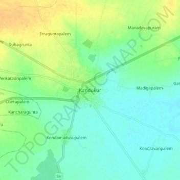
Naam: Topografische kaart Kandukur, hoogte, reliëf.
Gemiddelde hoogte: 18 m
Minimale hoogte: 7 m
Maximale hoogte: 36 m
Kandukuru (earlier known as Skandapuri) is located at 15°12′59″N 79°54′15″E / 15.2165°N 79.9042°E / 15.2165; 79.9042. It has an average elevation of 13 metres (43 ft). Kandukur was a part of the erstwhile Nellore district and was then included in the newly carved out Prakasam District in 1970. Later as a part of the district's reorganization in 2022, it is now merged with the residual SPSR Nellore district. The total geographical area of Kandukur Municipality is 37.63 sq km.
Andere topografische kaarten
Klik op een kaart om zijn topografie, zijn hoogte en zijn reliëf te bekijken.
Chuttugunta
India > Andhra Pradesh > Kandukur
Chuttugunta, Kandukur, Sri Potti Sriramulu Nellore District, Andhra Pradesh, India
Gemiddelde hoogte: 10 m
Kandukur
India > Andhra Pradesh > Kandukur
Kandukur, Sri Potti Sriramulu Nellore, Andhra Pradesh, 523105, India
Gemiddelde hoogte: 20 m