
Topografische kaart Drogheda
Interactieve kaart
Klik op de kaart om de hoogte weer te geven.
Over deze kaart
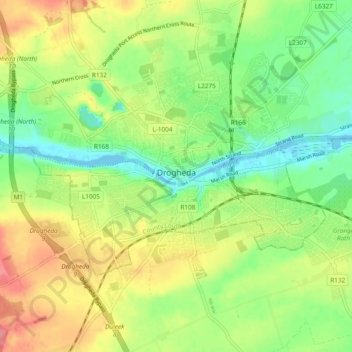
Naam: Topografische kaart Drogheda, hoogte, reliëf.
Locatie: Drogheda, County Louth, Leinster, Ireland (53.69442 -6.39292 53.73425 -6.29826)
Gemiddelde hoogte: 34 m
Minimale hoogte: -1 m
Maximale hoogte: 77 m
Andere topografische kaarten
Klik op een kaart om zijn topografie, zijn hoogte en zijn reliëf te bekijken.
Termonfeckin
Termonfeckin, Termonfeckin ED, The Borough District of Drogheda, County Louth, Leinster, Ireland
Gemiddelde hoogte: 16 m
Baltray
Baltray, Termonfeckin ED, The Borough District of Drogheda, County Louth, Leinster, Ireland
Gemiddelde hoogte: 3 m
Tullyallen
Tullyallen, St. Peter's ED, The Borough District of Drogheda, County Louth, Leinster, Ireland
Gemiddelde hoogte: 49 m
The Borough District of Drogheda
The Borough District of Drogheda, County Louth, Leinster, Ireland
Gemiddelde hoogte: 50 m
Dundalk Poor Law Union
Dundalk Poor Law Union, County Louth, Leinster, Ireland
Gemiddelde hoogte: 74 m
Drogheda
Ireland > County Louth > Drogheda
Drogheda, The Borough District of Drogheda, County Louth, Leinster, A92DKR0, Ireland
Gemiddelde hoogte: 38 m
The Municipal District of Dundalk
The Municipal District of Dundalk, County Louth, Leinster, Ireland
Gemiddelde hoogte: 68 m
Dundalk
Ireland > County Louth > Dundalk
Dundalk, The Municipal District of Dundalk, County Louth, Leinster, A91 RC44, Ireland
Gemiddelde hoogte: 16 m
Bellurgan
Bellurgan, Ballymascanlan ED, The Municipal District of Dundalk, County Louth, Leinster, Ireland
Gemiddelde hoogte: 52 m
Coole
Coole, Ardee Rural ED, The Municipal District of Ardee, County Louth, Leinster, Ireland
Gemiddelde hoogte: 32 m
Galroostown
Galroostown, Termonfeckin ED, The Borough District of Drogheda, County Louth, Leinster, Ireland
Gemiddelde hoogte: 66 m
Carlingford
Ireland > County Louth > Carlingford
Carlingford, The Municipal District of Dundalk, County Louth, Leinster, A91 TRR6, Ireland
Gemiddelde hoogte: 84 m