
Topografische kaart Devil's Punchbowl
Interactieve kaart
Klik op de kaart om de hoogte weer te geven.
Over deze kaart
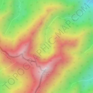
Naam: Topografische kaart Devil's Punchbowl, hoogte, reliëf.
Gemiddelde hoogte: 1.497 m
Minimale hoogte: 1.013 m
Maximale hoogte: 1.937 m
Andere topografische kaarten
Klik op een kaart om zijn topografie, zijn hoogte en zijn reliëf te bekijken.
Weed
United States > California > Siskiyou County
Weed, Siskiyou County, California, 96094, United States
Gemiddelde hoogte: 1.116 m
Happy Camp
United States > California > Siskiyou County
Happy Camp, Siskiyou County, CAL Fire Northern Region, California, United States
Gemiddelde hoogte: 470 m
Chilcoot Pass
United States > California > Siskiyou County
Chilcoot Pass, Siskiyou County, CAL Fire Northern Region, California, United States
Gemiddelde hoogte: 2.102 m
Mount Shasta City Park
United States > California > Siskiyou County > Mount Shasta
Mount Shasta City Park, Mount Shasta, Siskiyou County, CAL Fire Northern Region, California, United States
Gemiddelde hoogte: 1.126 m
Hornbrook
United States > California > Siskiyou County
Hornbrook, Siskiyou County, CAL Fire Northern Region, California, United States
Gemiddelde hoogte: 704 m
Erickson
United States > California > Siskiyou County > Erickson
Erickson, Siskiyou County, California, United States
Gemiddelde hoogte: 1.562 m