
Topografische kaart Crisfield
Interactieve kaart
Klik op de kaart om de hoogte weer te geven.
Over deze kaart
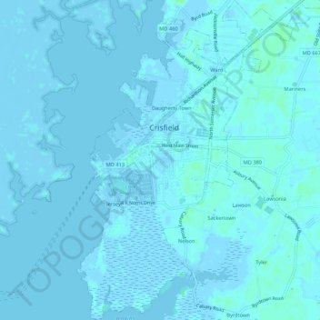
Naam: Topografische kaart Crisfield, hoogte, reliëf.
Locatie: Crisfield, Somerset County, Maryland, 21817, United States (37.95890 -75.87424 38.00094 -75.82563)
Gemiddelde hoogte: 1 m
Minimale hoogte: -4 m
Maximale hoogte: 7 m
Crisfield is a very compact city, with little vacant land. According to the United States Census Bureau, the city has a total area of 3.06 square miles (7.93 km2), of which 1.62 square miles (4.20 km2) (53.0%) is land and 1.44 square miles (3.73 km2) (47.0%) is water. As one of the southern points on the Delmarva Peninsula and one very close to the Chesapeake Bay, the city is extremely flat, with the elevation never rising above 3 feet (0.91 m).
Andere topografische kaarten
Klik op een kaart om zijn topografie, zijn hoogte en zijn reliëf te bekijken.
Princess Anne
United States > Maryland > Somerset County
Princess Anne, Somerset County, Maryland, 21853, United States
Gemiddelde hoogte: 5 m
Smith Island
United States > Maryland > Somerset County > Tylerton
Smith Island, Tylerton, Somerset County, Maryland, United States
Gemiddelde hoogte: 0 m
Eden
United States > Maryland > Somerset County
Eden, Somerset County, Maryland, 21822, United States
Gemiddelde hoogte: 8 m
Marion
United States > Maryland > Somerset County
Marion, Somerset County, Maryland, 21838, United States
Gemiddelde hoogte: 2 m
Westover
United States > Maryland > Somerset County
Westover, Somerset County, Maryland, 21890, United States
Gemiddelde hoogte: 4 m