
Topografische kaart Town of Pence
Interactieve kaart
Klik op de kaart om de hoogte weer te geven.
Over deze kaart
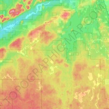
Naam: Topografische kaart Town of Pence, hoogte, reliëf.
Locatie: Town of Pence, Iron County, Wisconsin, United States (46.28350 -90.30084 46.44311 -90.21623)
Gemiddelde hoogte: 485 m
Minimale hoogte: 418 m
Maximale hoogte: 558 m
Andere topografische kaarten
Klik op een kaart om zijn topografie, zijn hoogte en zijn reliëf te bekijken.
Montreal
United States > Wisconsin > Iron County
Montreal, Iron County, Wisconsin, United States
Gemiddelde hoogte: 464 m
Iron Belt
United States > Wisconsin > Iron County
Iron Belt, Town of Knight, Iron County, Wisconsin, 54536, United States
Gemiddelde hoogte: 475 m
Town of Gurney
United States > Wisconsin > Iron County
Town of Gurney, Iron County, Wisconsin, United States
Gemiddelde hoogte: 318 m
Powell
United States > Wisconsin > Iron County
Powell, Town of Sherman, Iron County, Wisconsin, United States
Gemiddelde hoogte: 487 m
Saxon
United States > Wisconsin > Iron County
Saxon, Town of Saxon, Iron County, Wisconsin, 54559, United States
Gemiddelde hoogte: 339 m
Payment Lake
United States > Wisconsin > Iron County > Town of Mercer
Payment Lake, Town of Mercer, Iron County, Wisconsin, United States
Gemiddelde hoogte: 495 m
Upson
United States > Wisconsin > Iron County
Upson, Town of Anderson, Iron County, Wisconsin, United States
Gemiddelde hoogte: 462 m
Hurley
United States > Wisconsin > Iron County
Hurley, Iron County, Wisconsin, United States
Gemiddelde hoogte: 455 m
Town of Anderson
United States > Wisconsin > Iron County
Town of Anderson, Iron County, Wisconsin, United States
Gemiddelde hoogte: 467 m
Town of Mercer
United States > Wisconsin > Iron County
Town of Mercer, Iron County, Wisconsin, 54547, United States
Gemiddelde hoogte: 493 m
Manitowish River
United States > Wisconsin > Iron County > Town of Mercer > Manitowish
Manitowish River, Manitowish, Town of Mercer, Iron County, Wisconsin, United States
Gemiddelde hoogte: 486 m