
Doe een donatie
Rust jezelf uit voor je volgende avontuur:
Als Amazon-partner verdient deze site een commissie op in aanmerking komende aankopen, zonder extra kosten voor jou.
Topografische kaart Vashon Island
Klik op de kaart om de hoogte weer te geven.
Doe een donatie
Rust jezelf uit voor je volgende avontuur:
Als Amazon-partner verdient deze site een commissie op in aanmerking komende aankopen, zonder extra kosten voor jou.
Vashon Island
Vashon Island features a diverse topography characterized by rolling hills, lush forests, and scenic waterfronts. The island rises gently from sea level to elevations reaching around 500 feet (approximately 150 meters) at its highest point, providing sweeping views of Puget Sound and the surrounding mountains. The terrain includes a mix of grassy meadows, dense woodlands, and rocky shorelines, creating a varied landscape that supports a rich array of flora and fauna. Additionally, the coastline is dotted with sandy beaches and tide pools, offering a dynamic interaction between land and sea. The combination of these natural features contributes to the island's serene beauty and ecological diversity.
Doe een donatie
Rust jezelf uit voor je volgende avontuur:
Als Amazon-partner verdient deze site een commissie op in aanmerking komende aankopen, zonder extra kosten voor jou.
Over deze kaart
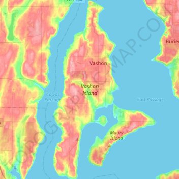
Naam: Topografische kaart Vashon Island, hoogte, reliëf.
Gemiddelde hoogte: 46 m
Minimale hoogte: -4 m
Maximale hoogte: 154 m
Doe een donatie
Rust jezelf uit voor je volgende avontuur:
Als Amazon-partner verdient deze site een commissie op in aanmerking komende aankopen, zonder extra kosten voor jou.