
Doe een donatie
Rust jezelf uit voor je volgende avontuur:
Als Amazon-partner verdient deze site een commissie op in aanmerking komende aankopen, zonder extra kosten voor jou.
Topografische kaart Britannia Beach
Klik op de kaart om de hoogte weer te geven.
Doe een donatie
Rust jezelf uit voor je volgende avontuur:
Als Amazon-partner verdient deze site een commissie op in aanmerking komende aankopen, zonder extra kosten voor jou.
Over deze kaart
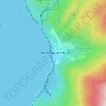
Naam: Topografische kaart Britannia Beach, hoogte, reliëf.
Gemiddelde hoogte: 208 m
Minimale hoogte: -1 m
Maximale hoogte: 1.009 m
Doe een donatie
Rust jezelf uit voor je volgende avontuur:
Als Amazon-partner verdient deze site een commissie op in aanmerking komende aankopen, zonder extra kosten voor jou.
Andere topografische kaarten
Klik op een kaart om zijn topografie, zijn hoogte en zijn reliëf te bekijken.
Garibaldi Lake
Canada > British Columbia > Squamish-Lillooet Regional District > Area D (Elaho/Garibaldi)
All recreational activities in the area are governed by the regulations of Garibaldi Provincial Park. Primary access to the lake is via the 9 km (5.5 mi) long Garibaldi Lake Trail, which gains approximately 920 m (3,020 ft) of elevation from the Rubble Creek Trailhead. There are campgrounds and day-use…
Gemiddelde hoogte: 1.620 m
Elfin Lakes
Canada > British Columbia > Squamish-Lillooet Regional District > Area D (Elaho/Garibaldi)
Gemiddelde hoogte: 1.331 m
Cheekye River
Canada > British Columbia > Squamish-Lillooet Regional District > Area D (Elaho/Garibaldi)
Gemiddelde hoogte: 634 m
Deeks Lake
Canada > British Columbia > Squamish-Lillooet Regional District > Area D (Elaho/Garibaldi)
Gemiddelde hoogte: 1.237 m
Doe een donatie
Rust jezelf uit voor je volgende avontuur:
Als Amazon-partner verdient deze site een commissie op in aanmerking komende aankopen, zonder extra kosten voor jou.
Minaty Bay
Canada > British Columbia > Squamish-Lillooet Regional District > Area D (Elaho/Garibaldi)
Gemiddelde hoogte: 91 m
Callaghan Lake Provincial Park
Canada > British Columbia > Squamish-Lillooet Regional District > Area D (Elaho/Garibaldi)
Gemiddelde hoogte: 1.455 m
Helm Glacier
Canada > British Columbia > Squamish-Lillooet Regional District > Area D (Elaho/Garibaldi)
Gemiddelde hoogte: 1.949 m
Sentinel Glacier
Canada > British Columbia > Squamish-Lillooet Regional District > Area D (Elaho/Garibaldi)
Gemiddelde hoogte: 1.856 m
Doe een donatie
Rust jezelf uit voor je volgende avontuur:
Als Amazon-partner verdient deze site een commissie op in aanmerking komende aankopen, zonder extra kosten voor jou.
Garibaldi Neve
Canada > British Columbia > Squamish-Lillooet Regional District > Area D (Elaho/Garibaldi)
Gemiddelde hoogte: 1.792 m
Barrier Lake
Canada > British Columbia > Squamish-Lillooet Regional District > Area D (Elaho/Garibaldi)
Gemiddelde hoogte: 1.405 m
Watersprite Lake
Canada > British Columbia > Squamish-Lillooet Regional District > Area D (Elaho/Garibaldi)
Gemiddelde hoogte: 1.591 m