
Topografische kaart Mount Marcy
Interactieve kaart
Klik op de kaart om de hoogte weer te geven.
Over deze kaart
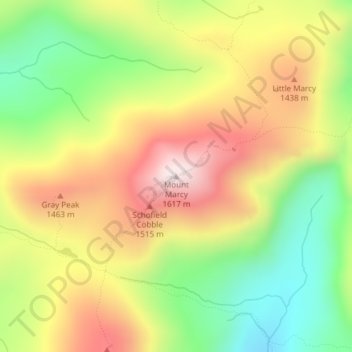
Naam: Topografische kaart Mount Marcy, hoogte, reliëf.
Gemiddelde hoogte: 1.289 m
Minimale hoogte: 985 m
Maximale hoogte: 1.615 m
Mount Marcy (Mohawk: Tewawe’éstha) is the highest point in the U.S. state of New York, with an elevation of 5,343.1 feet (1,628.6 m). It is located in the Town of Keene in Essex County. The mountain is in the heart of the Adirondack High Peaks region of the High Peaks Wilderness Area. Its stature and expansive views make it a popular destination for hikers, who crowd its summit in the summer months.
Andere topografische kaarten
Klik op een kaart om zijn topografie, zijn hoogte en zijn reliëf te bekijken.
Cascade Mountain
United States > New York > Essex County > Town of Keene
Cascade Mountain, Cascade Mountain Trail, Town of Keene, Essex County, New York, United States
Gemiddelde hoogte: 946 m