
Topografische kaart Thrissur
Interactieve kaart
Klik op de kaart om de hoogte weer te geven.
Over deze kaart
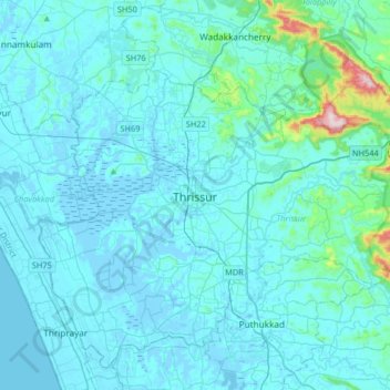
Naam: Topografische kaart Thrissur, hoogte, reliëf.
Locatie: Thrissur, Thrissur District, Kerala, 680001, India (10.36701 76.05462 10.68701 76.37462)
Gemiddelde hoogte: 36 m
Minimale hoogte: -6 m
Maximale hoogte: 516 m
Thrissur is the headquarters of Thrissur district, in the centre of the Indian state of Kerala. The city is 75 km north-east of Kochi, 133 km south-west of Coimbatore, 124 km south-east of Kozhikode and 151 km north of Changanacherry. The city is located in a hillock called Thekkinkadu Maidan which is the second highest point in city after the Vilangan Hills. The city has an average altitude of 2.83 metres above sea level.
Andere topografische kaarten
Klik op een kaart om zijn topografie, zijn hoogte en zijn reliëf te bekijken.
Madakkathara
India > Kerala > Thrissur > Thanikkudam
Madakkathara, Thanikkudam, Thrissur, Thrissur District, Kerala, India
Gemiddelde hoogte: 56 m
Kolazhy
India > Kerala > Thrissur > Mulakunnathukavu
Kolazhy, Mulakunnathukavu, Thrissur, Thrissur district, Kerala, India
Gemiddelde hoogte: 12 m