
Topografische kaart Bunclody Parish
Interactieve kaart
Klik op de kaart om de hoogte weer te geven.
Over deze kaart
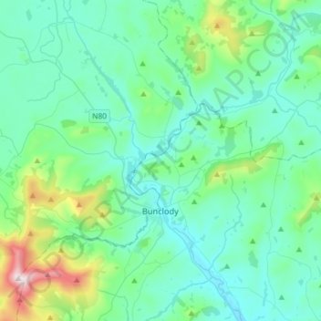
Naam: Topografische kaart Bunclody Parish, hoogte, reliëf.
Locatie: Bunclody Parish, County Wexford, Leinster, Y21 E1T6, Ireland (52.59472 -6.78152 52.77048 -6.51094)
Gemiddelde hoogte: 141 m
Minimale hoogte: 16 m
Maximale hoogte: 788 m
Andere topografische kaarten
Klik op een kaart om zijn topografie, zijn hoogte en zijn reliëf te bekijken.
Gorey
Gorey, The Municipal District of Gorey — Kilmuckridge, County Wexford, Leinster, Ireland
Gemiddelde hoogte: 62 m
Lough
Ireland > County Wexford > New Ross Municipal District
Lough, Duncormick ED, New Ross Municipal District, County Wexford, Leinster, Ireland
Gemiddelde hoogte: 13 m
Bridgetown
Bridgetown, The Borough District of Wexford, County Wexford, Leinster, Ireland
Gemiddelde hoogte: 10 m
Slad
Slad, Kilscoran ED, The Borough District of Wexford, County Wexford, Leinster, Ireland
Gemiddelde hoogte: 21 m
The Cahore Polders and Dunes
The Cahore Polders and Dunes, R742, Cahore ED, The Municipal District of Gorey — Kilmuckridge, County Wexford, Leinster, Ireland
Gemiddelde hoogte: 4 m
Ballywater
Ballywater, Kilpatrick ED, The Borough District of Wexford, County Wexford, Leinster, Ireland
Gemiddelde hoogte: 47 m
Kilmuckridge
Kilmuckridge, The Municipal District of Gorey — Kilmuckridge, County Wexford, Leinster, Ireland
Gemiddelde hoogte: 43 m
Oulart
Oulart, The Municipal District of Gorey — Kilmuckridge, County Wexford, Leinster, Ireland
Gemiddelde hoogte: 98 m
Old Ross
Old Ross, The Municipal District of New Ross, County Wexford, Leinster, Y35 EPH0, Ireland
Gemiddelde hoogte: 87 m
Bowling Green
Ireland > County Wexford > New Ross
Bowling Green, Irishtown, New Ross Urban ED, New Ross, County Wexford, Leinster, Y34 WR12, Ireland
Gemiddelde hoogte: 40 m
Castlemoyle
Castlemoyle, New Ross Rural ED, The Municipal District of New Ross, County Wexford, Leinster, Ireland
Gemiddelde hoogte: 40 m
Meelgarrow
Meelgarrow, Templeludigan ED, The Municipal District of New Ross, County Wexford, Leinster, Ireland
Gemiddelde hoogte: 119 m
The Municipal District of Enniscorthy
The Municipal District of Enniscorthy, County Wexford, Leinster, Ireland
Gemiddelde hoogte: 108 m
St. Mary's
Ireland > County Wexford > Wexford
St. Mary's, Wexford, The Borough District of Wexford, County Wexford, Leinster, Y35 FV48, Ireland
Gemiddelde hoogte: 14 m
Enniscorthy
Enniscorthy, Bellefield, Enniscorthy Rural ED, The Municipal District of Enniscorthy, County Wexford, Leinster, Ireland
Gemiddelde hoogte: 31 m
The Borough District of Wexford
The Borough District of Wexford, County Wexford, Leinster, Ireland
Gemiddelde hoogte: 29 m
Glenduff
Glenduff, Forth ED, The Borough District of Wexford, County Wexford, Leinster, Ireland
Gemiddelde hoogte: 45 m
Tara Hill
Tara Hill, The Municipal District of Gorey — Kilmuckridge, County Wexford, Leinster, Ireland
Gemiddelde hoogte: 77 m
Ramsgrange
Ireland > County Wexford > Ramsgrange
Ramsgrange, The Municipal District of New Ross, County Wexford, Leinster, Y34 CY63, Ireland
Gemiddelde hoogte: 51 m
Ballyprecas
Ballyprecas, Newtownbarry ED, The Municipal District of Enniscorthy, County Wexford, Leinster, Ireland
Gemiddelde hoogte: 94 m
Wexford
Ireland > County Wexford > Wexford
Wexford, The Borough District of Wexford, County Wexford, Leinster, Ireland
Gemiddelde hoogte: 23 m
Wheelagower
Wheelagower, Rossard ED, The Municipal District of Enniscorthy, County Wexford, Leinster, Ireland
Gemiddelde hoogte: 136 m
The Municipal District of New Ross
The Municipal District of New Ross, County Wexford, Leinster, Ireland
Gemiddelde hoogte: 63 m
Gorey
Gorey, Gorey Urban ED, The Municipal District of Gorey — Kilmuckridge, County Wexford, Leinster, Ireland
Gemiddelde hoogte: 60 m
Redhouse
Redhouse, New Ross Rural ED, The Municipal District of New Ross, County Wexford, Leinster, Ireland
Gemiddelde hoogte: 52 m
Enniscorthy
Ireland > County Wexford > Enniscorthy
Enniscorthy, The Municipal District of Enniscorthy, County Wexford, Leinster, Y21 YV83, Ireland
Gemiddelde hoogte: 44 m
Bann
Bann, Ballymore ED, The Municipal District of Gorey — Kilmuckridge, County Wexford, Leinster, Y21 E8D5, Ireland
Gemiddelde hoogte: 52 m
Rosbercon ED
Ireland > County Wexford > New Ross
Rosbercon ED, New Ross, County Wexford, Leinster, Ireland
Gemiddelde hoogte: 37 m