
Topografische kaart Old Fort
Interactieve kaart
Klik op de kaart om de hoogte weer te geven.
Over deze kaart
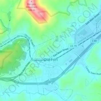
Naam: Topografische kaart Old Fort, hoogte, reliëf.
Locatie: Old Fort, McDowell County, North Carolina, United States (35.61726 -82.19397 35.64572 -82.15928)
Gemiddelde hoogte: 474 m
Minimale hoogte: 422 m
Maximale hoogte: 672 m
Andere topografische kaarten
Klik op een kaart om zijn topografie, zijn hoogte en zijn reliëf te bekijken.
West Marion
United States > North Carolina > McDowell County
West Marion, McDowell County, North Carolina, 28752, United States
Gemiddelde hoogte: 449 m
Marion
United States > North Carolina > McDowell County
Marion, McDowell County, North Carolina, 28752, United States
Gemiddelde hoogte: 435 m
Nebo
United States > North Carolina > McDowell County
Nebo, McDowell County, North Carolina, 28761, United States
Gemiddelde hoogte: 394 m
Little Switzerland
United States > North Carolina > McDowell County
Little Switzerland, McDowell County, North Carolina, 28749, United States
Gemiddelde hoogte: 935 m