
Topografische kaart Budd Lake
Interactieve kaart
Klik op de kaart om de hoogte weer te geven.
Over deze kaart
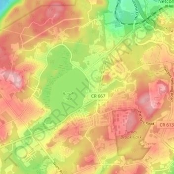
Naam: Topografische kaart Budd Lake, hoogte, reliëf.
Gemiddelde hoogte: 313 m
Minimale hoogte: 223 m
Maximale hoogte: 378 m
Budd Lake, which the community is named after, is the source of the South Branch Raritan River. A glacial lake at an elevation of 933 feet (284 m), Budd Lake has a surface area of 374 acres (1.51 km2). It is 7–12 feet deep, and can have large algal blooms. The bog, created by thousands of years of decaying plant material, supports wetland plants such as black spruce and tamarack, which grow on the floating mass. The lake is recharged through groundwater seepage through a series of wetlands, and serves as the headwaters of the Raritan River's South Branch. It is closely bordered by U.S. Route 46 to the south, and Sand Shore Road to the east.
Andere topografische kaarten
Klik op een kaart om zijn topografie, zijn hoogte en zijn reliëf te bekijken.
Bartley
United States > New Jersey > Morris County > Mount Olive
Bartley, Mount Olive, Morris County, New Jersey, 07836, United States
Gemiddelde hoogte: 231 m
Flanders
United States > New Jersey > Morris County > Mount Olive
Flanders, Mount Olive, Morris County, New Jersey, 07836, United States
Gemiddelde hoogte: 255 m