
Topografische kaart Florence
Interactieve kaart
Klik op de kaart om de hoogte weer te geven.
Over deze kaart
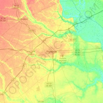
Naam: Topografische kaart Florence, hoogte, reliëf.
Gemiddelde hoogte: 35 m
Minimale hoogte: 9 m
Maximale hoogte: 62 m
Florence is located in the coastal plain of South Carolina. It is in the northeastern part of the state and the northern part of Florence County. The average elevation above sea level is around 140 ft (43 m). Jeffries Creek is a tributary of the Great Pee Dee River and is the main waterway that flows through the city, passing south of the city center. According to the United States Census Bureau, the city has a total area of 23.49 square miles (60.8 km2), of which 23.39 square miles (60.6 km2) is land and 0.09 square miles (0.23 km2) (0.38%) is water.
Andere topografische kaarten
Klik op een kaart om zijn topografie, zijn hoogte en zijn reliëf te bekijken.
Florence
United States > South Carolina > Florence County
Florence, Florence County, South Carolina, United States
Gemiddelde hoogte: 38 m
Country Manor
United States > South Carolina > Florence County > Florence
Country Manor, Florence, Florence County, South Carolina, 29505, United States
Gemiddelde hoogte: 29 m
Deerfield
United States > South Carolina > Florence County > Florence
Deerfield, Florence, Florence County, South Carolina, 29504, United States
Gemiddelde hoogte: 36 m
Dew Park
United States > South Carolina > Florence County > Lake City > Kelley Heights
Dew Park, Kelley Heights, Lake City, Florence County, South Carolina, 29560, United States
Gemiddelde hoogte: 23 m