
Topografische kaart Ponholz
Interactieve kaart
Klik op de kaart om de hoogte weer te geven.
Over deze kaart
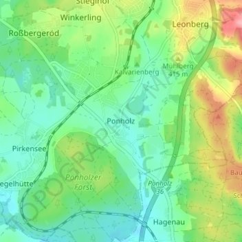
Naam: Topografische kaart Ponholz, hoogte, reliëf.
Gemiddelde hoogte: 382 m
Minimale hoogte: 345 m
Maximale hoogte: 459 m
Andere topografische kaarten
Klik op een kaart om zijn topografie, zijn hoogte en zijn reliëf te bekijken.
Roßbach
Deutschland > Bayern > Landkreis Schwandorf > Maxhütte-Haidhof > Ponholz
Roßbach, Ponholz, Maxhütte-Haidhof, Landkreis Schwandorf, Bayern, 93142, Deutschland
Gemiddelde hoogte: 401 m
Schwarzhof
Deutschland > Bayern > Landkreis Schwandorf > Maxhütte-Haidhof > Ponholz
Schwarzhof, Ponholz, Maxhütte-Haidhof, Landkreis Schwandorf, Bayern, 93142, Deutschland
Gemiddelde hoogte: 384 m
Pirkensee
Deutschland > Bayern > Landkreis Schwandorf > Maxhütte-Haidhof
Pirkensee, Maxhütte-Haidhof, Landkreis Schwandorf, Bayern, 93142, Deutschland
Gemiddelde hoogte: 371 m