Geolokaliseren

Topografische kaart Netherfield

Klik op de kaart om de hoogte weer te geven.

👉 Easily get elevation data in JSON, GeoTIFF and KML formats using Elevation API
Bedankt voor het steunen van deze site ❤️
Doe een donatie

Rust jezelf uit voor je volgende avontuur:

Als Amazon-partner verdient deze site een commissie op in aanmerking komende aankopen, zonder extra kosten voor jou.

Over deze kaart

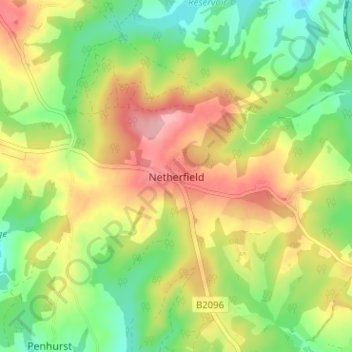
Naam: Topografische kaart Netherfield, hoogte, reliëf.

Locatie: Netherfield, Rother, East Sussex, England, TN33 9QE, United Kingdom (50.92308 0.41199 50.96308 0.45199)

Gemiddelde hoogte: 90 m

Minimale hoogte: 28 m

Maximale hoogte: 165 m

Andere topografische kaarten

Klik op een kaart om zijn topografie, zijn hoogte en zijn reliëf te bekijken.

Brede

United Kingdom > England > East Sussex > Rother

Gemiddelde hoogte: 40 m

Bodiam

United Kingdom > England > East Sussex > Rother

Gemiddelde hoogte: 27 m

Camber

United Kingdom > England > East Sussex > Rother

Gemiddelde hoogte: 1 m

Northiam

United Kingdom > England > East Sussex > Rother

Gemiddelde hoogte: 34 m

Ticehurst

United Kingdom > England > East Sussex > Rother

Gemiddelde hoogte: 81 m

Mountfield

United Kingdom > England > East Sussex > Rother > Mountfield

Gemiddelde hoogte: 63 m

Bewl Water

United Kingdom > England > East Sussex > Rother > Ticehurst

Gemiddelde hoogte: 92 m

Guestling

United Kingdom > England > East Sussex > Rother > Guestling

Gemiddelde hoogte: 39 m

Pett

United Kingdom > England > East Sussex > Rother

Gemiddelde hoogte: 21 m

Catsfield

United Kingdom > England > East Sussex > Rother > Catsfield

Gemiddelde hoogte: 53 m

Hurst Green

United Kingdom > England > East Sussex > Rother > Hurst Green

Gemiddelde hoogte: 54 m

Icklesham

United Kingdom > England > East Sussex > Rother

Gemiddelde hoogte: 26 m

Playden

United Kingdom > England > East Sussex > Rother

Gemiddelde hoogte: 17 m

Ring Wood

United Kingdom > England > East Sussex > Rother > Crowhurst

Gemiddelde hoogte: 24 m

Burwash

United Kingdom > England > East Sussex > Rother > Burwash

Gemiddelde hoogte: 83 m

Westfield

United Kingdom > England > East Sussex > Rother > Westfield

Gemiddelde hoogte: 48 m

Iden

United Kingdom > England > East Sussex > Rother > Iden

Gemiddelde hoogte: 17 m

Rye

United Kingdom > England > East Sussex > Rother > Playden

The town and its striking surroundings have frequently served as subject for painters, many of whose works are now on display in its art gallery. One of the earliest topographical panoramas, dating from the 17th century when the town was still an island port, is in the style of Hendrick Danckerts and on…

Gemiddelde hoogte: 7 m

Whatlington

United Kingdom > England > East Sussex > Rother

Gemiddelde hoogte: 53 m

Brightling

United Kingdom > England > East Sussex > Rother

Gemiddelde hoogte: 94 m

Sedlescombe

United Kingdom > England > East Sussex > Rother

Gemiddelde hoogte: 47 m

Peasmarsh

United Kingdom > England > East Sussex > Rother > Peasmarsh

Gemiddelde hoogte: 24 m

Udimore

United Kingdom > England > East Sussex > Rother

Gemiddelde hoogte: 23 m

Battle

United Kingdom > England > East Sussex > Rother > Battle

Gemiddelde hoogte: 66 m

Etchingham

United Kingdom > England > East Sussex > Rother

Gemiddelde hoogte: 46 m

Fairlight

United Kingdom > England > East Sussex > Rother

Gemiddelde hoogte: 47 m

Dallington

United Kingdom > England > East Sussex > Rother

Gemiddelde hoogte: 109 m

Camber Sands

United Kingdom > England > East Sussex > Rother > Camber

Gemiddelde hoogte: 2 m

Rye

United Kingdom > England > East Sussex > Rother > Playden

The town and its striking surroundings have frequently served as subject for painters, many of whose works are now on display in its art gallery. One of the earliest topographical panoramas, dating from the 17th century when the town was still an island port, is in the style of Hendrick Danckerts and on…

Gemiddelde hoogte: 7 m

Guestling

United Kingdom > England > East Sussex > Rother > Guestling

Gemiddelde hoogte: 40 m

Bewl Water

United Kingdom > England > East Sussex > Rother > Ticehurst

Gemiddelde hoogte: 92 m

Battle

United Kingdom > England > East Sussex > Rother > Battle

Gemiddelde hoogte: 66 m

Rye

United Kingdom > England > East Sussex > Rother

The town and its striking surroundings have frequently served as subject for painters, many of whose works are now on display in its art gallery. One of the earliest topographical panoramas, dating from the 17th century when the town was still an island port, is in the style of Hendrick Danckerts and on…

Gemiddelde hoogte: 7 m

Udimore

United Kingdom > England > East Sussex > Rother

Gemiddelde hoogte: 23 m

Catsfield

United Kingdom > England > East Sussex > Rother

Gemiddelde hoogte: 53 m

Battle

United Kingdom > England > East Sussex > Rother > Battle

Gemiddelde hoogte: 66 m

Rust jezelf uit voor je volgende avontuur:

👟Waterschoenen - Bescherming voor je voeten in rivieren en meren
📟Digitale Hoogtemeters - Meet exact je huidige hoogte boven zeeniveau
🪢Paracord - Sterk touw voor outdoor en survival gebruik
🌍Wereldbollen - Decoratieve en educatieve globes voor thuis
🚁Drones met Camera - Leg spectaculaire hoogtekaarten en beelden vast

Als Amazon-partner verdient deze site een commissie op in aanmerking komende aankopen, zonder extra kosten voor jou.