
Topografische kaart Cheaha Mountain
Interactieve kaart
Klik op de kaart om de hoogte weer te geven.
Over deze kaart
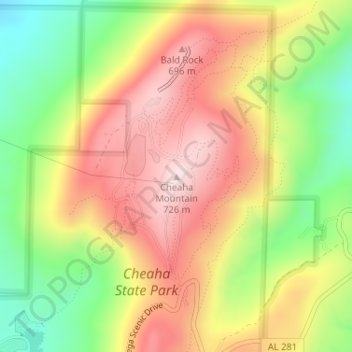
Naam: Topografische kaart Cheaha Mountain, hoogte, reliëf.
Locatie: Cheaha Mountain, Cleburne County, Alabama, United States (33.48557 -85.80883 33.48567 -85.80873)
Gemiddelde hoogte: 543 m
Minimale hoogte: 332 m
Maximale hoogte: 733 m
The highest point is marked with a USGS benchmark in front of Bunker Tower, a stone Civilian Conservation Corps building with an observation deck on top. The CCC also constructed a road to Cheaha, but the road has been closed for years. The old road is known as CC Road and contains interesting ruins. Near the peak is Bald Rock, which was recently improved with a wheelchair-accessible wooden walkway that provides an impressive overlook of the surrounding region. The entire area gives an impression of being at a much higher elevation than it actually is, in part because of the relatively low elevation of the adjacent area to the west.
Andere topografische kaarten
Klik op een kaart om zijn topografie, zijn hoogte en zijn reliëf te bekijken.
Ai
United States > Alabama > Cleburne County
Ai, Cleburne County, Alabama, United States
Gemiddelde hoogte: 298 m
Abernathy
United States > Alabama > Cleburne County
Abernathy, Cleburne County, Alabama, United States
Gemiddelde hoogte: 296 m
Hollis Crossroads
United States > Alabama > Cleburne County
Hollis Crossroads, Cleburne County, Alabama, United States
Gemiddelde hoogte: 266 m
Liberty Hill
United States > Alabama > Cleburne County
Liberty Hill, Cleburne County, Alabama, United States
Gemiddelde hoogte: 313 m
Abel
United States > Alabama > Cleburne County
Abel, Cleburne County, Alabama, United States
Gemiddelde hoogte: 306 m
Chulafinnee
United States > Alabama > Cleburne County
Chulafinnee, Cleburne County, Alabama, United States
Gemiddelde hoogte: 269 m
Edwardsville
United States > Alabama > Cleburne County
Edwardsville, Cleburne County, Alabama, 36261, United States
Gemiddelde hoogte: 294 m
Ranburne
United States > Alabama > Cleburne County
Ranburne, Cleburne County, Alabama, United States
Gemiddelde hoogte: 303 m
Hopewell
United States > Alabama > Cleburne County
Hopewell, Cleburne County, Alabama, United States
Gemiddelde hoogte: 327 m
Muscadine
United States > Alabama > Cleburne County
Muscadine, Cleburne County, Alabama, 36269, United States
Gemiddelde hoogte: 309 m
Trickem
United States > Alabama > Cleburne County
Trickem, Cleburne County, Alabama, United States
Gemiddelde hoogte: 335 m
Cheaha State Park
United States > Alabama > Cleburne County
Cheaha State Park, Cleburne County, Alabama, United States
Gemiddelde hoogte: 386 m
Heflin
United States > Alabama > Cleburne County
Heflin, Cleburne County, Alabama, United States
Gemiddelde hoogte: 302 m
Fruithurst
United States > Alabama > Cleburne County
Fruithurst, Cleburne County, Alabama, United States
Gemiddelde hoogte: 330 m
Oak Level
United States > Alabama > Cleburne County > Oak Level
Oak Level, Cleburne County, Alabama, United States
Gemiddelde hoogte: 308 m
Fruithurst
United States > Alabama > Cleburne County > Fruithurst
Fruithurst, Cleburne County, Alabama, United States
Gemiddelde hoogte: 330 m