
Doe een donatie
Rust jezelf uit voor je volgende avontuur:
Als Amazon-partner verdient deze site een commissie op in aanmerking komende aankopen, zonder extra kosten voor jou.
Topografische kaart Kullaberg
Klik op de kaart om de hoogte weer te geven.
Doe een donatie
Rust jezelf uit voor je volgende avontuur:
Als Amazon-partner verdient deze site een commissie op in aanmerking komende aankopen, zonder extra kosten voor jou.
Kullaberg
Kullaberg (Swedish pronunciation: [kɵlaˈbærj]) is a peninsula and nature reserve of land protruding into the Kattegat in Höganäs Municipality near the town of Mölle in southwest Sweden. The site in the province of Skåne is an area of considerable biodiversity supporting a number of rare species and has been designated as an Important Bird Area (IBA) in Sweden as well as a Special Protection Area (SPA). The terrain is dominated by steep cliffs rising from the sea and rocky outcrops on the ridge above, the highest elevation being Håkull at 188 metres. Ridgetop vegetation includes a mixed hardwood broadleaf forest consisting of birch, beech, oak and pine trees with an understory of hawthorn, juniper, wild honeysuckle and blackthorn. Among the notable rare plants are spring vetchling, Lathyrus sphaericus.
Doe een donatie
Rust jezelf uit voor je volgende avontuur:
Als Amazon-partner verdient deze site een commissie op in aanmerking komende aankopen, zonder extra kosten voor jou.
Over deze kaart
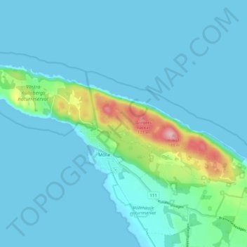
Naam: Topografische kaart Kullaberg, hoogte, reliëf.
Locatie: Kullaberg, Mölle, Höganäs kommun, Skåne County, 263 77, Sweden (56.27783 12.45335 56.30169 12.55388)
Gemiddelde hoogte: 22 m
Minimale hoogte: 0 m
Maximale hoogte: 174 m
Doe een donatie
Rust jezelf uit voor je volgende avontuur:
Als Amazon-partner verdient deze site een commissie op in aanmerking komende aankopen, zonder extra kosten voor jou.