
Topografische kaart Siedlec
Interactieve kaart
Klik op de kaart om de hoogte weer te geven.
Over deze kaart
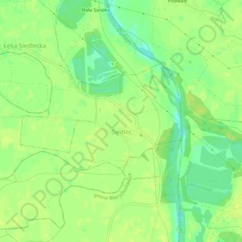
Naam: Topografische kaart Siedlec, hoogte, reliëf.
Gemiddelde hoogte: 184 m
Minimale hoogte: 173 m
Maximale hoogte: 188 m
Andere topografische kaarten
Klik op een kaart om zijn topografie, zijn hoogte en zijn reliëf te bekijken.
Piotrkowice
Poland > Lesser Poland Voivodeship > Tarnów County
Piotrkowice, gmina Tuchów, Tarnów County, Lesser Poland Voivodeship, Poland
Gemiddelde hoogte: 286 m
Dwudniaki
Poland > Lesser Poland Voivodeship > Tarnów County > Wierzchosławice
Dwudniaki, Wierzchosławice, gmina Wierzchosławice, Tarnów County, Lesser Poland Voivodeship, 33-122, Poland
Gemiddelde hoogte: 192 m
Skała
Poland > Lesser Poland Voivodeship > Tarnów County > Koszyce Małe
Skała, Koszyce Małe, gmina Tarnów, Tarnów County, Lesser Poland Voivodeship, 33-111, Poland
Gemiddelde hoogte: 231 m
Żabno
Poland > Lesser Poland Voivodeship > Tarnów County
Żabno, gmina Żabno, Tarnów County, Lesser Poland Voivodeship, 33-240, Poland
Gemiddelde hoogte: 186 m