
Topografische kaart Cabilao Island
Interactieve kaart
Klik op de kaart om de hoogte weer te geven.
Over deze kaart
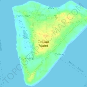
Naam: Topografische kaart Cabilao Island, hoogte, reliëf.
Gemiddelde hoogte: 6 m
Minimale hoogte: -1 m
Maximale hoogte: 24 m
Andere topografische kaarten
Klik op een kaart om zijn topografie, zijn hoogte en zijn reliëf te bekijken.
Loboc River
Philippines > Bohol > Tagbilaran
Loboc River, Tagbilaran, Bohol, Central Visayas, Philippines
Gemiddelde hoogte: 199 m
Loboc River
Philippines > Bohol > Tagbilaran
Loboc River, Tagbilaran, Bohol, Central Visayas, 6316, Philippines
Gemiddelde hoogte: 28 m
Cancostino Island
Philippines > Bohol > Tagbilaran
Cancostino Island, Tagbilaran, Bohol, Central Visayas, 6329, Philippines
Gemiddelde hoogte: 89 m
Cabgan Islet
Philippines > Bohol > Tagbilaran
Cabgan Islet, Tagbilaran, Bohol, Central Visayas, 6329, Philippines
Gemiddelde hoogte: 90 m
Catang Island
Philippines > Bohol > Tagbilaran
Catang Island, Tagbilaran, Bohol, Central Visayas, Philippines
Gemiddelde hoogte: 79 m
Mantatao Island
Philippines > Bohol > Tagbilaran
Mantatao Island, Tagbilaran, Bohol, Central Visayas, Philippines
Gemiddelde hoogte: 0 m
Silo Island
Philippines > Bohol > Tagbilaran
Silo Island, Tagbilaran, Bohol, Central Visayas, 6330, Philippines
Gemiddelde hoogte: 90 m
Sandingan Island
Philippines > Bohol > Tagbilaran
Sandingan Island, Tagbilaran, Bohol, Central Visayas, Philippines
Gemiddelde hoogte: 10 m