
Topografische kaart Flatwoods
Interactieve kaart
Klik op de kaart om de hoogte weer te geven.
Over deze kaart
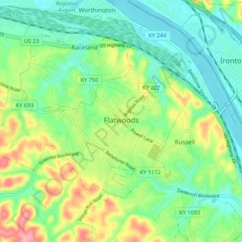
Naam: Topografische kaart Flatwoods, hoogte, reliëf.
Locatie: Flatwoods, Greenup County, Kentucky, United States (38.50385 -82.77101 38.54070 -82.69707)
Gemiddelde hoogte: 194 m
Minimale hoogte: 156 m
Maximale hoogte: 270 m
The area now known as Flatwoods was originally named "Advance": Advance Methodist Church formed a Sunday school beginning in 1860. The name was later changed to "Cheap", after John Cheap, a blind clergyman. The original farming community returned to the name of "Advance" when a post office was established in 1918. In 1938, the post office was renamed "Flatwoods", and the town was incorporated the same year under that name. Flatwoods is named for the area's unique topography, a belt of flat wooded land in the ancient Teays River valley on an elevation of approximately 650 feet (200 m) or higher, just south of and 150 feet (46 m) higher than the Ohio River valley. The availability of flat level land and low tax rates made Flatwoods a local hot spot of new construction in the 1950s and 1960s, when many upper-middle-class tract housing developments were built and quickly inhabited. A main contributor to Flatwoods' growth was the fact that nearby Ashland had developed much of its available land prior to 1960, with little new construction possible within its corporation limits.
Andere topografische kaarten
Klik op een kaart om zijn topografie, zijn hoogte en zijn reliëf te bekijken.
Bellefonte
United States > Kentucky > Greenup County
Bellefonte, Greenup County, Kentucky, United States
Gemiddelde hoogte: 188 m
Lloyd
United States > Kentucky > Greenup County > Lloyd
Lloyd, Greenup County, Kentucky, 45629, United States
Gemiddelde hoogte: 188 m